

A developing weather system over the southeastern Bay of Bengal is showing signs of further intensification and could become a severe cyclonic storm by November 18, according to the latest forecast information. The system is expected to move generally northwestwards while gradually strengthening over the Bay of Bengal during the coming days.
The low-pressure area that was previously located over the southeastern Bay of Bengal developed into a well-marked low-pressure area.
According to the latest projections, the system is very likely to intensify into a depression over the southeastern Bay of Bengal within the next 24 hours. Further strengthening is expected afterwards, with the possibility of it developing into a cyclonic storm over the central and adjoining west-central Bay of Bengal around November 16.
The estimated central pressure of the system is currently around 1009 hPa. Associated maximum sustained winds are estimated at 15 knots, with gusts reaching approximately 25 knots.
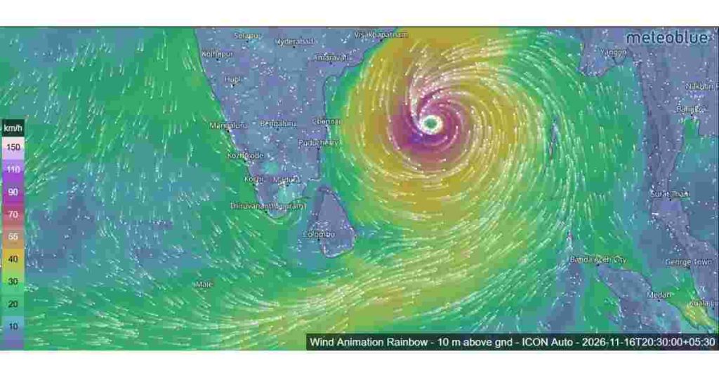
Expected Development and Movement
The forecast table indicates a gradual increase in the system’s strength as it moves towards the northwest. November 15, it is expected to reach the depression stage, with sustained winds of 40–50 kmph and gusts up to 60 kmph.
Further intensification is anticipated on November 16. The system could develop into a deep depression , with winds reaching 50–60 kmph. it is forecast to become a cyclonic storm, with sustained winds of 60–70 kmph and gusts up to 80 kmph.
The system is projected to strengthen further on November 17, with wind speeds potentially increasing to 70–80 kmph. The latest forecast table indicates that it could reach severe cyclonic storm intensity on November 18, with maximum sustained winds of 75–85 kmph and gusts reaching 95 kmph.
Satellite Observations and Atmospheric Conditions
Satellite observations from INSAT-3DS have identified a developing atmospheric vortex over the southeastern Bay of Bengal, centred near 6.8°N and 87.8°E. The system has been assigned an intensity classification of T1.0.
Scattered to broken low- and medium-level clouds, together with areas of intense to very intense convection, have been observed over the southern Bay of Bengal, South Andaman Sea, Andaman and Nicobar Islands and Sri Lanka. Cloud-top temperatures are estimated to range between -70°C and -90°C, indicating strong convective activity.
The Madden-Julian Oscillation (MJO) is another factor supporting the development of this system. It is currently in phase 3, with an amplitude greater than one, and is expected to move into phase 4 between November 16 and 21. These atmospheric conditions are considered favourable for enhanced convection and cyclone development over the Bay of Bengal during November 14–21.
Uncertainty Remains Over the Future Track
Although several forecast models indicate further intensification, there are still differences in their predictions regarding the system’s future direction, strength and possible landfall location.
Most models suggest that the system will initially move northwestwards before turning north-northwestwards towards the northern Andhra Pradesh coast of India. Some model guidance also indicates a possible movement towards the Myanmar coast.
There are also differences in the predicted maximum intensity. While several models suggest peak wind speeds of around 40 knots, the CMC and IMD GFS models indicate the possibility of stronger development, with winds reaching approximately 65 knots.
Possible Weather Effects on Sri Lanka
The developing system is also an important weather feature to monitor for Sri Lanka. Satellite observations have already identified convective cloud activity over the island and surrounding maritime regions.
However, the available forecast information does not establish a definite direct impact or landfall over Sri Lanka. The system’s movement and intensity will need to be monitored as updated forecasts become available.
The coming days will be particularly important in determining how quickly the low-pressure system develops and which direction it eventually takes. Changes in its track and intensity could influence weather conditions across parts of the Bay of Bengal and surrounding regions.
| Date and time (IST) | Expected system | Wind speed |
|---|---|---|
| Nov 14 – 8:30 AM | Well-marked low | 35–45 kmph |
| Nov 14 – 5:30 PM | Well-marked low | 35–45 kmph |
| Nov 15 – 5:30 AM | Depression | 40–50 kmph |
| Nov 15 – 5:30 PM | Depression | 45–55 kmph |
| Nov 16 – 5:30 AM | Deep depression | 50–60 kmph |
| Nov 16 – 5:30 PM | Cyclonic storm | 60–70 kmph |
| Nov 17 – 5:30 AM | Cyclonic storm | 65–75 kmph |
| Nov 17 – 5:30 PM | Cyclonic storm | 70–80 kmph |
| Nov 18 – 5:30 AM | Severe cyclonic storm | 75–85 kmph |