
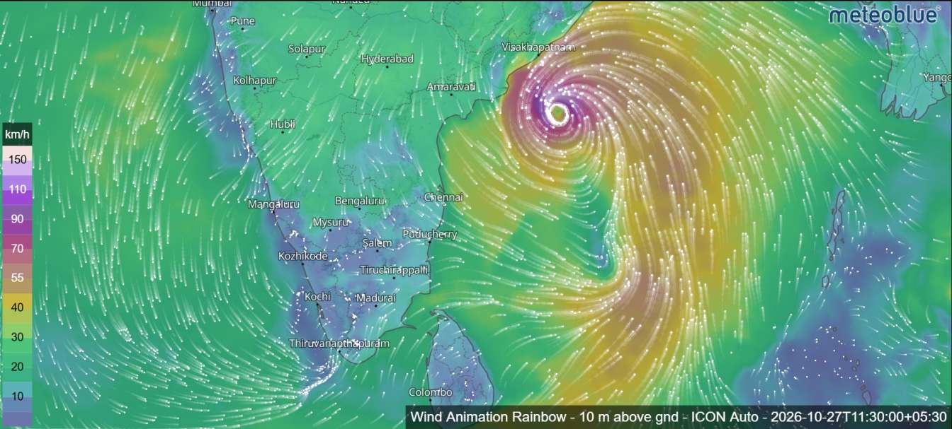
Cyclone Arnab Intensifies Over Bay of Bengal; Red Alert Issued for Andhra Pradesh Coast
Very Severe Cyclonic Storm Arnab is moving towards the Andhra Pradesh coastline after intensifying over the west-central Bay of Bengal, with a red-level cyclone warning issued for coastal Andhra Pradesh and adjoining southern Odisha, according to the latest tropical cyclone bulletin.
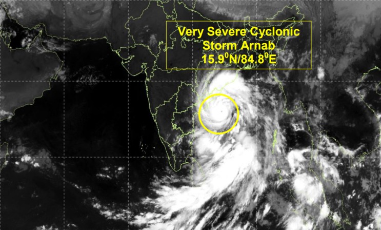
The storm is forecast to move northwestwards before approaching the coast between Bapatla and Visakhapatnam, near Yanam, around October 28. The latest advisory warns of powerful winds, dangerous sea conditions and possible coastal flooding from storm surge.
Meteorologists are closely monitoring the system as its movement slows near the coast and its projected track begins to curve towards the north-northwest.
Cyclone Arnab: Latest Location and Movement

At 00:00 UTC on October 27, Cyclone Arnab was centred near 15.9°N latitude and 84.8°E longitude over the west-central Bay of Bengal.
The system had moved westward at approximately 22 km/h during the preceding six hours. According to the bulletin, the cyclone was located approximately:
- 300 km east-southeast of Kakinada, Andhra Pradesh.
- 300 km east of Machilipatnam, Andhra Pradesh.
- 460 km southeast of Gopalpur, Odisha.
- 980 km west-northwest of Sri Vijaya Puram in the Andaman Islands.
The storm is expected to move west-northwestward before gradually turning northwest and north-northwest as it approaches the coastline. Changes in its speed and direction could influence the timing and location of landfall.
Cyclone Arnab Forecast: Possible Landfall on October 28
The latest forecast indicates that Cyclone Arnab could cross the Andhra Pradesh coast between Bapatla and Visakhapatnam, close to Yanam, around 06:00 UTC on October 28.
This corresponds to approximately 11:30 a.m. Indian Standard Time and Sri Lanka Standard Time.
The bulletin identifies this coastal stretch as the principal area of concern. However, the precise landfall point and timing may change as the cyclone moves closer to land.
The storm is expected to weaken after landfall as it moves inland and encounters less favourable conditions. Even after its winds begin to decrease, heavy rainfall, flooding and other weather-related hazards may continue in affected areas.
How Strong Could Cyclone Arnab Become?
The cyclone has developed in an environment that meteorologists consider favourable for further intensification. The bulletin’s forecast table indicates that wind speeds could increase substantially during October 27 before the system weakens as it approaches and crosses the coast.

The forecast table provides the following progression:
| Forecast time (UTC) | Expected intensity | Sustained wind speed |
|---|---|---|
| Oct 27, 00:00 | Very severe cyclonic storm | 130–140 km/h |
| Oct 27, 06:00 | Very severe cyclonic storm | 150–160 km/h |
| Oct 27, 12:00 | Very severe cyclonic storm | 150–160 km/h |
| Oct 27, 18:00 | Very severe cyclonic storm | 135–145 km/h |
| Oct 28, 00:00 | Very severe cyclonic storm | 125–135 km/h |
| Oct 28, 06:00 | Very severe cyclonic storm | 90–100 km/h |
| Oct 28, 12:00 | Deep depression | 50–60 km/h |
These figures are taken from the forecast table in the supplied bulletin. Its accompanying narrative gives different wind-speed estimates, so the latest official advisory should be checked before these figures are treated as definitive.
The forecast highlights the possibility of a period of very strong winds before the cyclone reaches the coast. Residents in the warning area should follow official instructions and prepare for rapidly changing weather conditions.
Red-Level Cyclone Warning for Andhra Pradesh and Southern Odisha
The bulletin identifies the west-central Bay of Bengal and the adjoining coastal areas of Andhra Pradesh and southern Odisha as the main areas of concern.
Strong winds could damage trees, power lines, temporary structures and other exposed infrastructure. Coastal communities may also experience dangerous waves, rough seas and localised inundation.
Residents in low-lying coastal locations should monitor warnings from local authorities and be ready to move to designated safe locations if instructed.
Fishermen and maritime operators should follow the applicable restrictions and marine weather advisories. Going out to sea during dangerous conditions could put lives at risk.
Storm Surge Could Flood Low-Lying Coastal Areas
The advisory warns that a storm surge of approximately 1.0–1.5 metres above the astronomical tide is possible during landfall.
Low-lying coastal areas of East Godavari district and Yanam in Puducherry are identified as locations vulnerable to inundation.
Storm surge occurs when strong cyclone winds push seawater towards the coast, raising water levels above the normal tide. When combined with high tides and waves, this can allow seawater to move inland and flood exposed coastal areas.
The extent of any flooding will depend on the cyclone’s final track, intensity, timing and local coastal conditions.
Why Is Cyclone Arnab Intensifying?
Meteorological analysis in the bulletin points to several environmental conditions that may support the cyclone’s development.
Sea-surface temperatures are reported to be around 30°C over the east-central and west-central Bay of Bengal. Warm ocean water provides energy and moisture that can help tropical cyclones intensify.
The bulletin also describes favourable atmospheric circulation, increased low-level rotation and supportive moisture conditions around the storm. These factors may contribute to further strengthening before landfall.
However, changes in wind shear, the cyclone’s interaction with land and shifts in the surrounding atmospheric steering patterns could affect its intensity and direction.
The forecast also indicates that the cyclone may slow down and change direction as it approaches the coast, making continued monitoring particularly important.
Weather Conditions After Landfall
After crossing the Andhra Pradesh coast, Cyclone Arnab is forecast to weaken as it moves inland.
The bulletin suggests that the system could weaken into a depression during October 29 and become a well-marked low-pressure area by October 30.
Despite the expected weakening, the storm may continue to bring heavy rain and localised flooding to parts of eastern India. Waterlogged roads, falling trees and damage to infrastructure could remain concerns after the strongest winds have passed.
Residents should not assume that conditions are safe simply because the cyclone has weakened. Official warnings should be followed until authorities confirm that the danger has passed.
Safety Advice for Residents in Coastal Areas
As Cyclone Arnab approaches the coast, residents in potentially affected districts should take precautions:
- Follow the latest official cyclone warnings and evacuation instructions.
- Stay away from beaches, exposed coastlines and rough seas.
- Secure loose objects around homes and buildings.
- Keep drinking water, essential medicines, food and emergency lighting ready.
- Avoid flooded roads and areas affected by fallen trees or damaged power lines.
- Fishermen should comply with marine warnings and restrictions on fishing activities.
- Keep updated through official meteorological and disaster-management announcements.
People living in low-lying coastal areas should pay particular attention to storm-surge warnings and instructions from local authorities.
Cyclone Arnab: Latest Outlook
Cyclone Arnab remains a significant weather threat over the Bay of Bengal, with the latest bulletin forecasting a possible landfall between Bapatla and Visakhapatnam near Yanam on October 28.
The system could produce destructive winds and coastal flooding, while heavy rainfall may continue after it moves inland. The exact landfall location, timing and intensity remain subject to forecast changes.
Residents along the Andhra Pradesh and adjoining southern Odisha coasts should remain alert and rely on the latest official advisories for decisions about travel, fishing and personal safety.
Source: Tropical cyclone bulletin dated October 27, 2026, supplied for this report.
Forecast information is subject to change. Follow the latest updates from the relevant meteorological and disaster-management authorities.