
Sri Lanka Heavy Rain Expected in Northern and Eastern Provinces
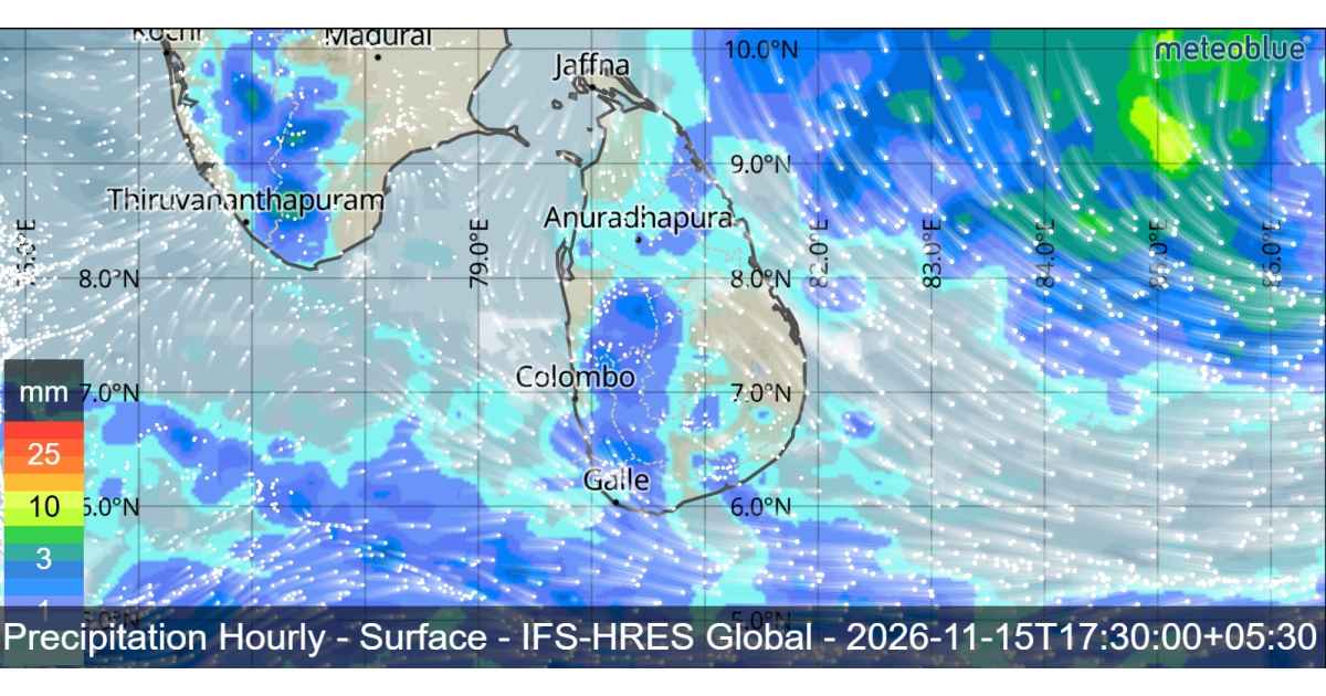
Cloudy weather and widespread rainfall are expected across Sri Lanka on Sunday, November 15, as a developing low-pressure system over the Bay of Bengal continues moving northwestwards. Heavy rainfall exceeding 75 mm is possible in some locations in the Northern and Eastern provinces, while the system is also expected to strengthen into a depression by tomorrow.
The low-pressure area was located approximately 650 km east of Batticaloa, over the Bay of Bengal. The system is expected to move northwestwards, away from the eastern coast of Sri Lanka, and is likely to intensify into a depression around November 15.
Under the influence of this developing weather system, cloudy skies are expected to prevail across the entire island tomorrow. Several areas will experience rainfall at different times of the day, with some provinces likely to receive fairly heavy showers.

Showers are expected at times in the Northern, North-Central, Eastern, Western and North-Western provinces, as well as in the Galle and Matara districts. Some locations in the Northern and Eastern provinces may receive fairly heavy rainfall exceeding 75 mm.
Meanwhile, showers or thundershowers may develop at a few places in the Uva and Central provinces and in the Hambantota district during the evening or night.
Misty conditions are also expected in some areas during the early morning hours. The Western, Sabaragamuwa, Central and Uva provinces, along with Galle, Matara and Kurunegala districts, may experience mist during this period.
The public is advised to take adequate precautions against temporary localized strong winds and lightning that may occur during thundershowers.
Bay of Bengal System May Develop Into a Cyclonic Storm
The developing low-pressure area is expected to intensify into a depression around November 15. Thereafter, the system is likely to strengthen further into a cyclonic storm over the central Bay of Bengal around November 16.
The system’s movement and intensification will remain important factors influencing regional weather conditions over the coming days.
Sri Lanka Sea Warning Issued for Fishing and Naval Communities
The Department of Meteorology has maintained its warning advising fishing and naval communities not to venture into the deep-sea areas bounded by 05°N–15°N and 80°E–90°E. The warning also covers sea areas extending from Kankasanthurai to Hambantota via Trincomalee and Pottuvil. It has been effective since 5.30 a.m. on November 14 and remains in force until further notice.
Those already operating in the specified sea areas are advised to move to safe locations.
Showers or thundershowers are expected in sea areas extending from Kankasanthurai to Galle via Trincomalee, Batticaloa and Hambantota.
Northeasterly or northerly winds will prevail around the island at speeds of 30–40 kmph. Winds may occasionally increase up to 60 kmph in sea areas from Kankasanthurai to Hambantota via Trincomalee and Batticaloa, while other surrounding sea areas may experience speeds of up to 50 kmph.
Sea conditions will be rough at times along the affected coastal stretch and fairly rough in other surrounding areas. During thundershowers, gusty winds reaching 60–70 kmph and very rough seas are possible.
Fishing and naval communities are urged to follow further official weather bulletins and updates as the Bay of Bengal system develops.
