

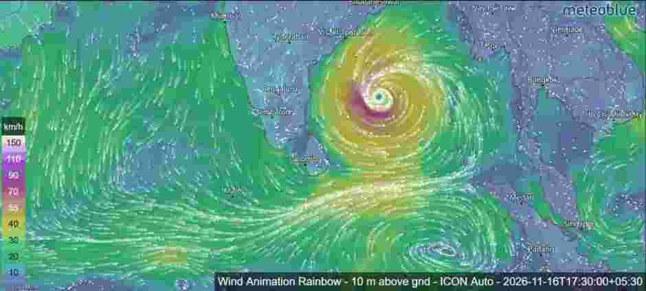
A developing weather system over the Bay of Bengal is expected to intensify significantly over the coming days, with forecasts indicating the possibility of a Very Severe Cyclonic Storm by November 18, 2026.
According to the latest weather bulletin issued on November 15, the depression over the southeast and adjoining southwest Bay of Bengal continued moving north-northwestwards at approximately 15 kmph during the previous six hours.November 15, the system was centred near 9.8°N latitude and 86.8°E longitude, approximately 620 km northeast of Trincomalee.
The system was also located around 680 km west-southwest of Sri Vijaya Puram in the Andaman and Nicobar Islands, and approximately 800 km east-southeast of Chennai, India.
Forecast guidance suggests that the depression will continue moving north-northwestwards while gradually strengthening. It is very likely to intensify into a Cyclonic Storm over the central parts of the south and adjoining west-central Bay of Bengal on November 16. Further strengthening into a Severe Cyclonic Storm is expected on November 17.
The system may subsequently intensify further, potentially reaching Very Severe Cyclonic Storm intensity over the west-central Bay of Bengal on November 18. It is then expected to continue moving northwestwards towards the Andhra Pradesh coast of India during the following two days.
Expected strengthening and wind speeds
| Date and time (Sri Lanka time) | Expected system intensity | Wind speed |
|---|---|---|
| Nov 15, 11:30 a.m. | Depression | 45–55 kmph, gusting to 65 |
| Nov 15, 11:30 p.m. | Deep Depression | 55–65 kmph, gusting to 75 |
| Nov 16, 11:30 a.m. | Cyclonic Storm | 60–70 kmph, gusting to 80 |
| Nov 16, 11:30 p.m. | Cyclonic Storm | 75–85 kmph, gusting to 95 |
| Nov 17, 11:30 a.m. | Severe Cyclonic Storm | 90–100 kmph, gusting to 110 |
| Nov 17, 11:30 p.m. | Severe Cyclonic Storm | 95–105 kmph, gusting to 115 |
| Nov 18, 11:30 a.m. | Severe Cyclonic Storm | 105–115 kmph, gusting to 125 |
| Nov 18, 11:30 p.m. | Very Severe Cyclonic Storm | 115–125 kmph, gusting to 135 |
| Nov 19, 11:30 a.m. | Very Severe Cyclonic Storm | 120–130 kmph, gusting to 145 |
If this forecast materialises, the system could reach maximum sustained wind speeds of 120–130 kmph, with gusts reaching approximately 145 kmph by November 19.
Atmospheric conditions favour further development
Satellite observations from INSAT-3DS indicate that the system has a well-defined atmospheric circulation over the southeast and adjoining southwest Bay of Bengal. The associated cloud pattern consists of scattered to broken low- and medium-level clouds, with embedded areas of intense to very intense convection.
These atmospheric conditions, together with favourable upper-level divergence and low-level convergence, are supporting the further development of the system.
The Madden-Julian Oscillation (MJO) is currently in Phase 3, with an amplitude greater than one. It is expected to move across Phase 4 between November 16 and 21. This atmospheric pattern is considered favourable for enhancing convective activity over the Bay of Bengal during this period.
The bulletin also highlights the influence of equatorial Rossby waves and Kelvin waves, alongside favourable atmospheric circulation patterns, which could support the intensification process over the coming days.

Forecast uncertainty remains
Despite the favourable conditions for intensification, some uncertainty remains regarding the system’s subsequent movement, further strengthening and eventual landfall location. Different numerical weather prediction models are showing variations in their projections.
Most of the models examined in the bulletin indicate a north-northwestward movement towards the northern Andhra Pradesh coast of India. The IMD Multi-Model Ensemble (MME) guidance also suggests a similar movement, with peak intensity potentially reaching around 65 knots.
The next few days will therefore be particularly important in determining the system’s eventual track and intensity.
Weather authorities will continue monitoring the depression as it develops over the Bay of Bengal. The forecast track and intensity may be updated as new satellite observations and numerical weather model guidance become available.
