
")
Issued at 05.30 a.m. on 06 January 2026
Weather conditions in the sea areas around Sri Lanka during the next 24 hours are expected to become more active as the low-level atmospheric disturbance in the Bay of Bengal, to the southeast of the island, has intensified into a low-pressure area, according to the Department of Meteorology. This development is expected to influence marine weather patterns across a wide stretch of sea areas surrounding the island, leading to increased cloudiness, frequent showers, stronger winds and rough sea conditions in several regions. Such low-pressure systems commonly affect the Bay of Bengal and often result in unsettled marine weather around Sri Lanka.
Showers are expected to occur at several places in the sea areas off the coast extending from Kankasanthurai to Matara via Trincomalee and Pottuvil. These eastern, northeastern and southeastern sea regions may experience intermittent rainfall throughout the forecast period, with cloudy conditions prevailing at times. In addition, showers or thundershowers may occur at several places in the other sea areas around the island during the evening or night, contributing to unsettled weather conditions across surrounding waters during these hours.
Winds over the sea areas around the island are expected to be mainly north-easterly in direction. Wind speeds will generally range between 30 and 40 kilometres per hour in most sea areas. However, wind speeds can increase at times, reaching between 50 and 60 kilometres per hour in the sea areas off the coast extending from Beruwala to Matara via Colombo, Puttalam, Kankasanthurai, Trincomalee and Pottuvil. These stronger winds are associated with the intensification of the low-pressure system and may lead to rapidly changing marine conditions across these coastal stretches.
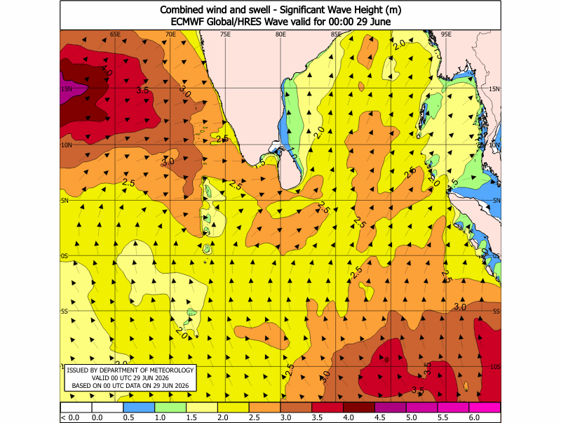
As a result of these wind conditions, the sea areas off the coast extending from Beruwala to Matara via Colombo, Puttalam, Kankasanthurai, Trincomalee and Pottuvil are expected to be rough at times during the next 24 hours. Increased wave activity and choppy sea surfaces may be observed in these areas, particularly in open sea regions. The other sea areas around the island may remain moderate, although conditions may vary depending on wind strength and rainfall activity.
In addition, wave heights may increase to about 2.5 to 3.0 metres in the sea areas off the coast extending from Kankasanthurai to Pottuvil via Trincomalee. This increase in wave height applies only to sea areas and does not affect land areas. Such wave conditions reflect the continued influence of the low-pressure system over the Bay of Bengal.
Naval and fishing communities operating in the sea areas around Sri Lanka are requested to remain attentive to future forecasts and official bulletins issued by the Department of Meteorology, as marine weather conditions may change depending on the development and movement of the low-pressure area.
