
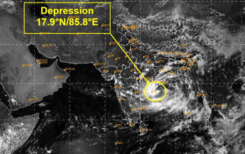
A depression over the westcentral and adjoining northwest Bay of Bengal is expected to strengthen into a deep depression during the next 12 hours, according to the latest tropical weather outlook issued by the Regional Specialised Meteorological Centre (RSMC), New Delhi.
The system was located over the westcentral and adjoining northwest Bay of Bengal at 8.45 a.m. on 22 September 2026. It had moved westwards at around 8 km/h during the previous six hours and was centred approximately 179 km east-northeast of Kalingapatnam, Andhra Pradesh, and about 270 km east of Visakhapatnam.

The latest outlook indicates that the system is likely to continue moving west-northwestwards and intensify into a deep depression over the westcentral and adjoining northwest Bay of Bengal during the next 12 hours.
It is then expected to move towards the north Andhra Pradesh–south Odisha coast. The system is likely to cross the coast between Visakhapatnam and Gopalpur as a deep depression between 18.00 UTC and 21.00 UTC on 23 September 2026.

System Expected to Maintain Strength
Forecast guidance shows the system maintaining deep-depression intensity through much of 23 September. Maximum sustained winds are forecast to reach around 55–60 km/h, with gusts up to 70–75 km/h during the period.
The sea conditions over the westcentral and adjoining northwest Bay of Bengal are expected to remain rough to very rough.
The latest satellite observations also show intense to very intense convection associated with the system. Convective cloud activity has been observed across parts of the Bay of Bengal and nearby areas, indicating continued development of the weather system.
Meteorological guidance suggests a high level of confidence in both the expected movement of the system and its continued intensification over the next several hours.
The system is expected to move west-northwestwards and approach the north Andhra Pradesh–south Odisha coast, with the latest forecast indicating landfall around 23 September.
Authorities and fishing communities in the affected sea areas are advised to closely monitor official weather bulletins as the system develops. Further changes in the system’s track and intensity will be reflected in subsequent forecasts.