
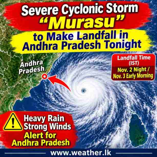
Severe Cyclonic Storm “Murasu” is moving northwestwards over the west-central and adjoining southwest Bay of Bengal and is expected to cross the south Andhra Pradesh coast of India as a Severe Cyclonic Storm during the late hours of November 2, 2026, according to the latest cyclone bulletin issued by the India Meteorological Department (IMD).
The storm has been moving northwestwards at a speed of approximately 25 kmph over the past six hours. The system was centred near latitude 13.9°N and longitude 81.8°E, approximately 200 km east-northeast of Chennai, 210 km east-southeast of Nellore, 270 km south-southeast of Machilipatnam, 220 km east-southeast of Kavali and 260 km southeast of Ongole.
The IMD forecasts that Murasu will continue moving northwestwards and cross the south Andhra Pradesh coast between Nellore and Narsapur, close to Ongole, during the period from 11:30 PM on November 2 to 3:30 AM on November 3 (IST). At the time of landfall, the system is expected to maintain maximum sustained wind speeds of 100–110 kmph, with gusts reaching 120 kmph.

Expected Intensity and Movement
According to the latest forecast, Murasu is expected to maintain its Severe Cyclonic Storm intensity throughout November 2. Its intensity is forecast to gradually decrease after crossing the Indian coastline.
The estimated central pressure of the system is 998 hPa, while the maximum sustained wind speed is around 50 knots, with gusts reaching 60 knots.
The forecast positions and intensities of Severe Cyclonic Storm Murasu are as follows:
| Date and time (IST) | Maximum sustained wind speed | Intensity |
|---|---|---|
| Nov 2 – 05:30 AM | 90–100 kmph, gusting to 110 kmph | Severe Cyclonic Storm |
| Nov 2 – 11:30 AM | 100–110 kmph, gusting to 120 kmph | Severe Cyclonic Storm |
| Nov 2 – 05:30 PM | 100–110 kmph, gusting to 120 kmph | Severe Cyclonic Storm |
| Nov 2 – 11:30 PM | 100–110 kmph, gusting to 120 kmph | Severe Cyclonic Storm |
| Nov 3 – 05:30 AM | 75–85 kmph, gusting to 95 kmph | Cyclonic Storm |
| Nov 3 – 05:30 PM | 50–60 kmph, gusting to 70 kmph | Deep Depression |
| Nov 4 – 05:30 AM | 40–50 kmph, gusting to 60 kmph | Depression |
Heavy Rainfall, Strong Winds and Storm Surge Threat
The cyclone is expected to bring strong winds, heavy rainfall and rough weather conditions to coastal areas of Andhra Pradesh and adjoining parts of Tamil Nadu.
The IMD has warned that a storm surge of approximately 1.0–1.5 metres above the astronomical tide is likely to inundate low-lying coastal areas of south Andhra Pradesh during landfall. The maximum storm surge is expected over Bapatla, Krishna and Prakasam districts.
Satellite observations indicate intense convective activity to the northwest of the cyclone centre. Scattered to broken low- and medium-level clouds with embedded intense to very intense convection are also observed over the southwest and west-central Bay of Bengal, adjoining coastal Andhra Pradesh and northeastern Tamil Nadu.
Environmental Conditions Supporting Intensification
Meteorological analysis indicates that several atmospheric and oceanic conditions are currently supporting the development and intensification of Murasu.
Warm sea surface temperatures of approximately 29°C over the Andaman Sea and the Bay of Bengal are providing favourable conditions for the cyclone. Low to moderate wind shear in the middle and upper atmospheric levels is also supporting the system’s intensification.
Weather models suggest that Murasu is likely to continue its northwestward movement until it approaches the south Andhra Pradesh coastline. Although there are some differences among international weather models regarding its exact movement and intensity, the overall forecast guidance supports landfall as a Severe Cyclonic Storm.
What About Sri Lanka?
Murasu is currently located over the Bay of Bengal and is forecast to move northwestwards towards the south Andhra Pradesh coast of India. Its expected landfall is over the Indian coastline rather than Sri Lanka.
However, the development and movement of this system remain important for monitoring regional weather conditions over the Bay of Bengal and surrounding areas. Changes in the cyclone’s movement and intensity may influence atmospheric conditions over the region.
The latest forecasts indicate that Murasu is likely to cross the south Andhra Pradesh coast during the late night of November 2 or early morning of November 3 (Sri Lanka and Indian Standard Time).
Further updates regarding the cyclone’s movement, intensity and associated weather conditions will be important as the system approaches the Indian coastline.