
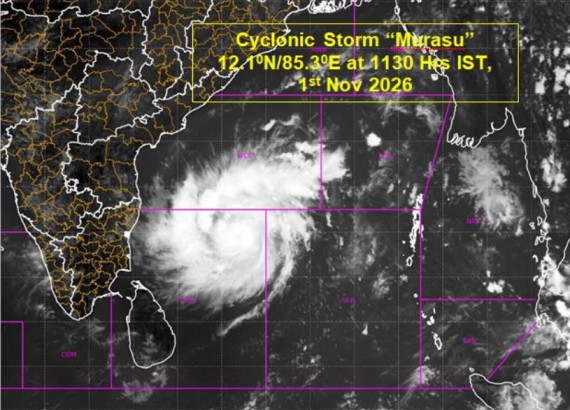
The deep depression over the southwest and adjoining southeast Bay of Bengal has intensified into Cyclonic Storm “Murasu”, according to the latest weather bulletin issued on November 1, 2026. The system is moving west-northwestwards and is expected to intensify further into a Severe Cyclonic Storm over the west-central Bay of Bengal by November 2.
According to the bulletin, the cyclone was centred at 06:00 UTC (11:30 a.m. Sri Lanka time) on November 1 over the southwest and adjoining west-central Bay of Bengal, near latitude 12.1°N and longitude 85.3°E. It was located approximately 560 km east-southeast of Chennai, 660 km south-southeast of Visakhapatnam and around 680 km east-southeast of Ongole along the Indian coastline.
The system has been moving west-northwestwards at approximately 23 kmph during the previous six hours. Current observations indicate that the maximum sustained wind speed is around 65–75 kmph, with gusts reaching 85 kmph.
Further Intensification Expected
Meteorological observations and numerical weather prediction models indicate favourable environmental conditions for further intensification of the cyclone.
Warm ocean waters, high sea surface temperatures of around 29°C, low vertical wind shear and strong atmospheric moisture are supporting the development of the system. Satellite imagery also indicates intense convective activity, with organised spiral cloud bands developing around the cyclone’s centre.
The Madden-Julian Oscillation (MJO), along with favourable upper-level atmospheric conditions, is also expected to contribute to the strengthening of the system over the coming days.
The latest analysis suggests that the cyclone is very likely to intensify into a Severe Cyclonic Storm around 0000 UTC on November 2, 2026.
Forecast Track and Expected Landfall
The cyclone is forecast to continue moving west-northwestwards before gradually changing its direction towards the northwest as it approaches the Indian coastline.
According to the forecast track provided in the bulletin, the system is expected to reach the west-central Bay of Bengal and strengthen further before approaching the south Andhra Pradesh coast.
The forecast indicates the following changes in the system’s intensity:
| Date and time (UTC) | Forecast intensity | Wind speed |
|---|---|---|
| Nov 1 – 0600 | Cyclonic Storm | 65–75 kmph |
| Nov 1 – 1200 | Cyclonic Storm | 70–80 kmph |
| Nov 1 – 1800 | Cyclonic Storm | 80–90 kmph |
| Nov 2 – 0000 | Severe Cyclonic Storm | 90–100 kmph |
| Nov 2 – 0600 | Severe Cyclonic Storm | 100–110 kmph |
| Nov 2 – 1800 | Severe Cyclonic Storm | 100–110 kmph |
| Nov 3 – 0600 | Cyclonic Storm | 80–90 kmph |
Wind speeds are maximum sustained surface winds, with higher gusts.
The India Meteorological Department’s subsequent forecast indicates that the system is likely to cross the south Andhra Pradesh coast between Nellore and Narsapur by the morning of November 3, with sustained winds of 100–110 kmph and gusts up to 120 kmph. Mausam+1
Storm Surge Warning for Coastal Andhra Pradesh
A storm surge of approximately 1.0 metre above the astronomical tide is considered likely to affect low-lying coastal areas of south Andhra Pradesh during landfall.
The Bapatla, Krishna and Prakasam districts are identified as areas where the maximum storm surge may occur. Such a rise in sea level could cause inundation of vulnerable coastal locations, particularly in low-lying areas.
Atmospheric and Oceanic Conditions Supporting Intensification
Several environmental factors are currently supporting the cyclone’s development. Sea surface temperatures are around 29°C over the Andaman Sea and the Bay of Bengal, providing favourable oceanic conditions.
The analysis also indicates strong low-level atmospheric convergence around the system, while vertical wind shear remains relatively low to moderate. These conditions are favourable for the organisation of deep convection and further strengthening.
Satellite imagery shows organised spiral cloud bands and intense convective activity to the northwest of the system’s centre. Cloud-top temperatures ranging from approximately -70°C to -90°C indicate strong thunderstorms associated with the cyclone.
The system is also influenced by upper-level atmospheric circulation patterns. An upper-tropospheric ridge extending across the region is expected to influence its movement, steering it towards the Andhra Pradesh coastline.
Possible Weather Impacts and Regional Monitoring
The development of Cyclone Murasu is expected to influence weather conditions across parts of eastern and southern India. Heavy to very heavy rainfall is possible over affected coastal regions, accompanied by strong winds and rough sea conditions.
The IMD’s marine bulletin indicates high sea conditions over the southwest Bay of Bengal and rough to very rough seas over the west-central Bay of Bengal. Fishermen and maritime operators in affected areas should follow official weather advisories. Mausam+1
For Sri Lanka, the movement and development of this system over the Bay of Bengal will remain important to monitor. Its movement, associated atmospheric circulation and changing wind patterns could influence regional weather conditions. However, the information in this bulletin does not establish a direct cyclone impact or landfall threat to Sri Lanka.
Weather conditions around Sri Lanka should therefore be monitored through updates issued by the Department of Meteorology.
