
Cyclone Arnab Nears Andhra Pradesh Landfall With Winds Up to 140 km/h
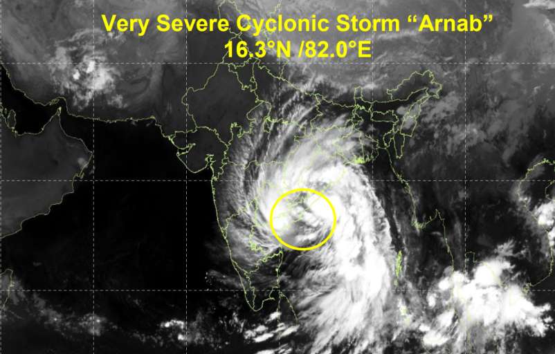
Cyclone Arnab intensified into a very severe cyclonic storm over the west-central Bay of Bengal and is approaching the Andhra Pradesh coast, with landfall expected near south of Yanam between Bapatla and Visakhapatnam. The India Meteorological Department (IMD) has warned of destructive winds, storm surges and flooding in low-lying coastal areas.
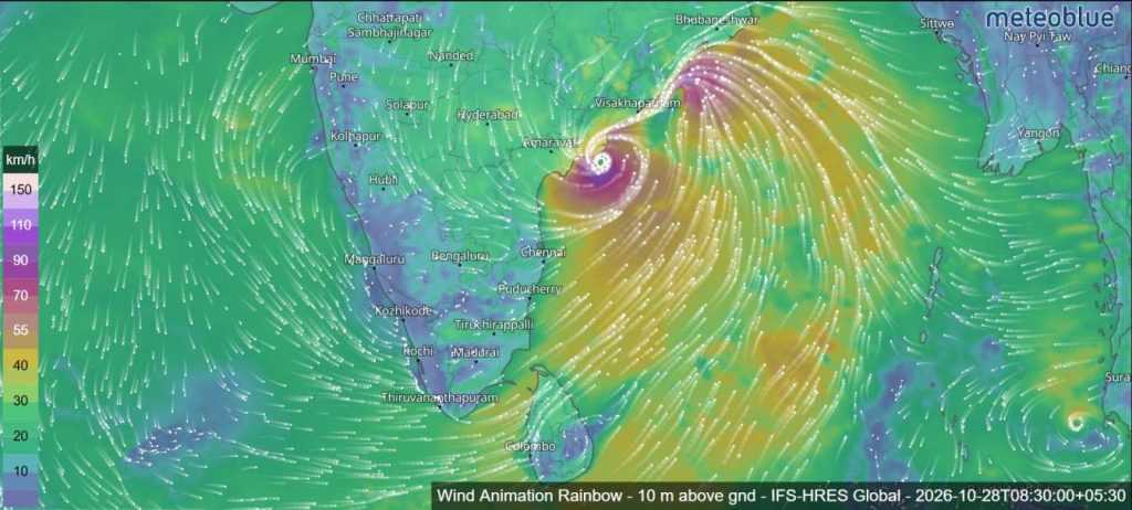
According to the IMD’s bulletin issued on October 28, 2026, the storm was located near latitude 16.4°N and longitude 82.0°E. Its centre was approximately 30 km east of Narsapur, 70 km south-southwest of Kakinada, 90 km east-northeast of Machilipatnam and 170 km east-northeast of Bapatla.

The very severe cyclonic storm had remained almost stationary for around three hours before the latest observation. However, forecasters expected it to resume moving northwestwards and cross the Andhra Pradesh and Yanam coasts within the following two hours.
The landfall process had already begun, with the storm’s northern spiral rainbands moving over land and its centre positioned very close to the coastline.
Cyclone Arnab Landfall Forecast and Wind Speeds
The IMD forecast that Cyclone Arnab would cross the coast between Bapatla and Visakhapatnam, close to the south of Yanam, with maximum sustained winds of 115–125 km/h and gusts reaching 140 km/h.
The system had an estimated central atmospheric pressure of 985 hPa. Its intensity was classified as a very severe cyclonic storm, with maximum sustained winds of approximately 65 knots and gusts reaching 75 knots.
However, observations from the Doppler Weather Radar at Machilipatnam indicated signs of weakening. The latest radar imagery showed a significant reduction in convection around the storm’s eyewall, particularly across its eastern and northern sectors. The eye was no longer visible in observation, while the northern outer rainbands were interacting with the land surface.
Meteorologists said these developments indicated that the storm was beginning to weaken as it approached and interacted with the coast.

Storm to Weaken Rapidly After Landfall
The IMD expected Cyclone Arnab to weaken gradually after moving inland across Andhra Pradesh and adjoining areas.
| Forecast time (October 28–30) | Expected intensity | Maximum sustained winds |
|---|---|---|
| October 28, 5:30 a.m. | Very severe cyclonic storm | 115–125 km/h |
| October 28, 11:30 a.m. | Cyclonic storm | 80–90 km/h |
| October 28, 5:30 p.m. | Deep depression | 55–65 km/h |
| October 28, 11:30 p.m. | Depression | 45–55 km/h |
| October 29, 5:30 a.m. | Depression | 30–40 km/h |
| October 30, 6:00 p.m. | Well-marked low-pressure area | 20–30 km/h |
The forecast indicates a substantial reduction in wind speeds after landfall. Gale-force winds were expected to gradually ease, although strong gusts and heavy rainfall could continue as the system moved inland.
The IMD also noted that increasing vertical wind shear over Andhra Pradesh and nearby inland areas would contribute to the storm’s weakening.
Storm Surge Threatens Kakinada and Yanam
Storm surge is among the major coastal hazards associated with Cyclone Arnab.
The IMD warned that a storm surge of approximately 1.5–2.5 metres above the astronomical tide could inundate low-lying coastal areas of Andhra Pradesh during landfall.
The highest surge was expected near Kakinada and Yanam, while a surge of approximately 2–3.5 metres was forecast along the mouth of the Godavari River.
These conditions could lead to seawater inundation in vulnerable coastal settlements, particularly in areas close to the shoreline and river mouths.
The forecast surge heights are above the predicted astronomical tide and should not be interpreted as the total water depth expected in every location. Actual inundation will depend on local terrain, tides and coastal conditions.
Sea Conditions Expected to Improve After Landfall
Sea conditions over the affected parts of the Bay of Bengal were expected to remain phenomenal until landfall during the morning of October 28.
Conditions were forecast to improve gradually after the storm moved inland. The sea was expected to become very high to high by the evening of October 28, followed by very rough to rough conditions by the morning of October 29.
Further gradual improvement was expected thereafter.
Despite the forecast weakening, hazardous coastal and offshore conditions could persist during and immediately after landfall.
Heavy Rain and Thunderstorms Across Eastern India
Satellite observations showed widespread cloud cover and intense to very intense convection across several parts of eastern and central India.
These included the northwest, central and southern Bay of Bengal, North Coastal Andhra Pradesh, Odisha, Jharkhand, Chhattisgarh, Gangetic West Bengal, southeast Bihar, eastern Madhya Pradesh and eastern Telangana.
Additional areas of moderate to intense convection included parts of the northeast Bay of Bengal, western Telangana, Bihar, southeastern Uttar Pradesh and Rayalaseema.
Satellite measurements indicated cloud-top temperatures as low as minus 70°C to minus 90°C in areas of intense convection, reflecting the presence of powerful storm clouds.
As Arnab moves inland, heavy rainfall and thunderstorms may affect areas along and near its projected path. The combination of rainfall, strong winds and coastal inundation could increase the risk of flooding and disruption in vulnerable locations.
Why Cyclone Arnab Intensified
The IMD’s analysis identified several atmospheric and oceanic factors that supported the storm’s development over the Bay of Bengal.
Sea-surface temperatures were approximately 30°C over the east-central and adjoining west-central Bay of Bengal, while temperatures along India’s eastern coast were around 29°C. Ocean heat content was estimated at 80–100 kJ/cm² across much of the Bay, with some areas recording 100–120 kJ/cm².
The Madden-Julian Oscillation (MJO), which influences tropical weather patterns, was in Phase 3 with an amplitude greater than one. Forecasters said this phase was favourable for increased atmospheric convection and the storm’s intensification before landfall.
Westerly wind anomalies, together with the influence of Equatorial Rossby and Kelvin waves, also contributed to a favourable environment for cyclone development.
However, the IMD expected conditions over land to become less favourable for maintaining the storm’s strength. Drier air, land interaction and increasing wind shear were forecast to accelerate its weakening after landfall.
What Happens Next?
The IMD’s latest assessment indicated high confidence in the storm’s observed location and intensity, with moderate-to-high confidence in its forecast track and future intensity.
Most numerical weather models suggested that the system would move northwestwards and could turn towards a more northerly direction after crossing the coast. Some differences remained among the models regarding the storm’s exact movement and intensity after landfall.
Authorities and coastal communities were advised to follow official weather bulletins and local emergency instructions as the cyclone approached the shoreline and moved inland.
Although Cyclone Arnab was expected to weaken after landfall, the immediate risks from powerful winds, heavy rainfall, storm surges and coastal flooding remained significant during the landfall period.
Source: India Meteorological Department (IMD), Very Severe Cyclonic Storm Arnab bulletin dated October 28, 2026.