
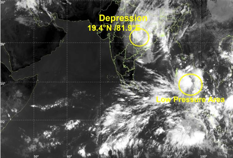
The remnants of Cyclone Arnab are moving northwards across central India, bringing squally winds and thunderstorms to parts of Chhattisgarh, Odisha and neighbouring states, while a separate low-pressure system over the South Andaman Sea is expected to strengthen over the coming days.
According to the India Meteorological Department (IMD), the depression left behind by Very Severe Cyclonic Storm Arnab moved northwards at approximately 18 km/h during the six hours leading up to 1:30 p.m. October 29, 2026.
At 8:30 a.m. , the system was centred over south Chhattisgarh and adjoining south Odisha, near latitude 19.4°N and longitude 81.9°E. It was located around 40 km north-northeast of Jagdalpur in Chhattisgarh, 150 km west-southwest of Bhawanipatna in Odisha, 180 km southwest of Titlagarh, 200 km south of Raipur and 310 km southwest of Sambalpur.
The expects the depression to continue moving generally northwards before weakening into a well-marked low-pressure area over north Chhattisgarh and adjoining northwestern Odisha around midday on October 29.
The system remains under continuous monitoring by the Doppler Weather Radar at Raipur.
Strong Winds Expected in Chhattisgarh and Odisha
Despite its weakening, the remnants of Cyclone Arnab are expected to produce squally weather across parts of eastern and central India.
Wind speeds of 45–55 km/h, with gusts reaching 65 km/h, are likely across the southern districts of Chhattisgarh, including Sukma, Dantewada, Bijapur and Bastar.
In Odisha, the affected areas include Gajapati, Kalahandi, Rayagada, Koraput and Malkangiri. Parts of northern Telangana, including Hanumakonda, Jangaon, Mulugu and Mahabubabad, may also experience strong, gusty winds.
These conditions are expected to continue until the afternoon of October 29 before gradually easing.
Along the West Bengal coast and over the adjoining northwestern Bay of Bengal, squally winds of 35–45 km/h, with gusts of 45–55 km/h, are forecast to persist until around noon on October 29.
Rain and Thunderstorms Across Several States
The IMD has reported widespread cloud cover associated with Arnab’s remnants and the low-pressure area over the Andhra Pradesh coast and adjoining west-central Bay of Bengal.
Areas potentially affected by intense thunderstorms include coastal Andhra Pradesh, Odisha, Chhattisgarh, Jharkhand, Gangetic West Bengal, Madhya Pradesh, Vidarbha, Telangana, Rayalaseema and parts of Bihar.
Moderate to intense convection has also been observed over parts of Karnataka, south Bihar and Uttar Pradesh.
The combination of moisture, atmospheric instability and the system’s movement may continue to support unsettled weather across these regions as the depression weakens inland.
Rough Seas Forecast Along West Bengal Coast
Marine conditions are also expected to remain hazardous in parts of the northwestern Bay of Bengal.
The IMD forecasts rough to very rough seas over the northwestern Bay of Bengal and along and off the West Bengal coast until approximately 11:30 a.m. on October 29, followed by gradual improvement.
Fishing and maritime communities should continue to monitor official marine weather bulletins and follow relevant safety instructions.
New Low-Pressure System May Strengthen Over Bay of Bengal
Meanwhile, a separate low-pressure area over the South Andaman Sea and adjoining areas remained in the same general region at 8:30 a.m. on October 29.
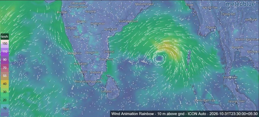
The expects this system to move north-northwestwards and develop into a well-marked low-pressure area over the next 24 hours.
It is then likely to move west-northwestwards and concentrate into a depression over the southeast Bay of Bengal and adjoining parts of the Andaman Sea during the following 24 hours.
If this forecast develops as expected, the new system could bring further unsettled weather to the Andaman Sea and Bay of Bengal.
Squally winds of 35–45 km/h, with gusts reaching 55 km/h, are forecast over the North Andaman Sea on October 29. Similar conditions are expected over the South Andaman Sea and the Andaman and Nicobar Islands, with winds potentially increasing to 40–50 km/h and gusts of 60 km/h on October 30.
Over the southeast Bay of Bengal and adjoining areas of the Andaman Sea, winds of 35–45 km/h, gusting to 55 km/h, are expected to strengthen to 45–55 km/h, with gusts up to 65 km/h, on October 31.
What Happens Next?
The IMD’s assessment indicates that Arnab’s remnants are likely to weaken further as they move northwards and interact with land. However, strong winds, thunderstorms and rough seas may persist temporarily in affected areas.
At the same time, meteorologists are monitoring the developing low-pressure system over the South Andaman Sea, which could become a depression over the southeast Bay of Bengal.
The IMD has assessed confidence in the current location and intensity of the systems, as well as their forecast movement and intensity, as high.
Residents, coastal communities and fishing operators are advised to follow the latest official weather forecasts and warnings as conditions evolve.
Source: India Meteorological Department (IMD), special tropical weather outlook issued on October 29, 2026.