
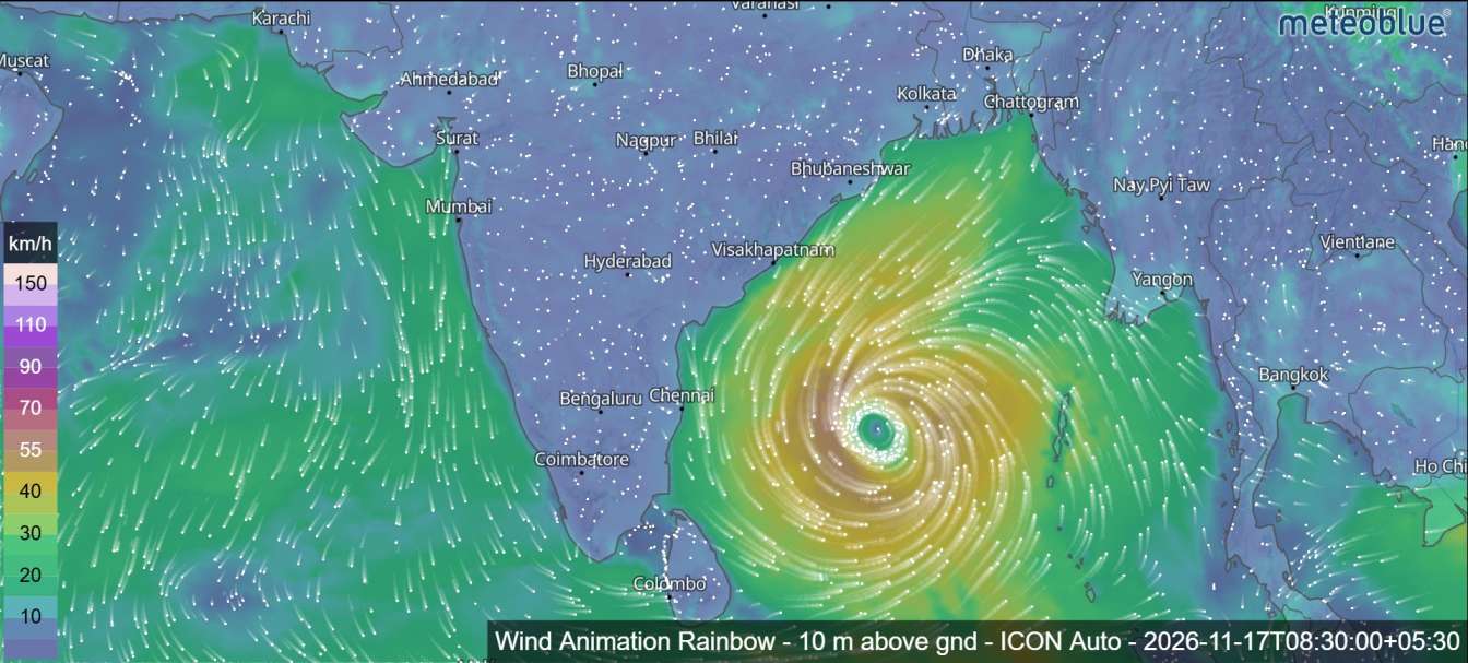
Cyclone Akvan Likely to Become a Very Severe Cyclonic Storm, Andhra Pradesh Landfall Expected on November 20
Cyclonic Storm Akvan is expected to strengthen further over the Bay of Bengal, potentially becoming a very severe cyclonic storm by November 19, with the latest forecast indicating a possible landfall along the Andhra Pradesh and Yanam coasts on November 20. The system is moving slowly north-northwestwards over the central parts of the south and adjoining west-central Bay of Bengal.
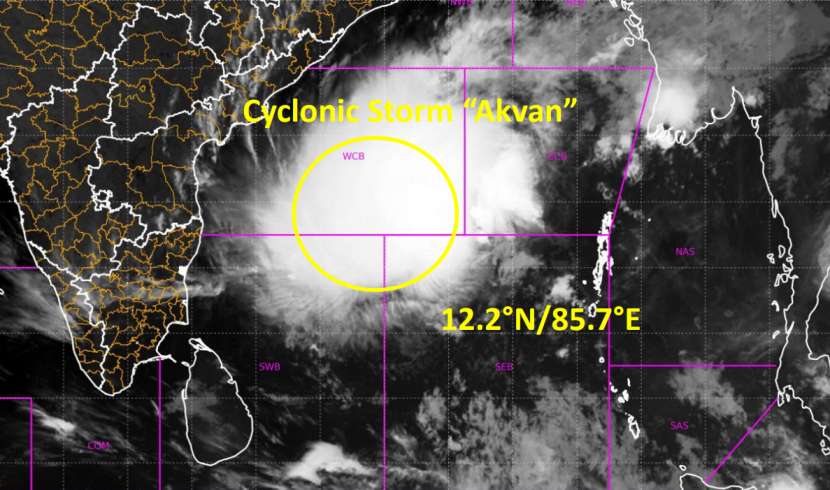
The cyclone remained practically stationary during the previous nine hours. The system was centred near latitude 12.2°N and longitude 85.7°E.
At that time, the storm was located approximately 610 km east of Chennai, 630 km northeast of Trincomalee in Sri Lanka, 660 km south of Machilipatnam, 670 km south-southeast of Visakhapatnam and 790 km south of Gopalpur in Odisha.
Akvan forecast to become a very severe cyclonic storm
According to the forecast, Cyclone Akvan is very likely to move north-northwestwards and intensify into a Severe Cyclonic Storm over the Westcentral Bay of Bengal around 5:30 p.m. on November 17.
The system is then expected to continue moving northwestwards while gaining further strength. Forecast guidance indicates that it could develop into a Very Severe Cyclonic Storm around 5:30 a.m. on November 19.
The maximum sustained wind speed is forecast to increase to 120–130 kmph, with gusts reaching up to 145 kmph.
Forecast Track and Intensity of Cyclone Akvan
The forecast positions and intensities indicate a gradual strengthening of the system as it moves towards the Indian coastline.
On November 17, the cyclone is expected to reach severe cyclonic storm intensity. By November 19, it is forecast to become a very severe cyclonic storm.
The following table presents the forecast positions, wind speeds and cyclone categories, with all original UTC times converted into Sri Lanka Standard Time.

Andhra Pradesh Landfall Expected on November 20
One of the most significant developments in the latest forecast is the possibility of Cyclone Akvan crossing the Andhra Pradesh and Yanam coasts.
The system is likely to continue moving northwestwards and cross the coastline between Nellore and Tuni around 11:30 a.m. on November 20, 2026.
At the time of landfall, the maximum sustained wind speed is expected to reach 120–130 kmph, with gusts reaching up to 145 kmph.
After crossing the coast, the system is forecast to gradually weaken. By November 21, it is expected to decrease to cyclonic storm intensity before further weakening into a depression.
Atmospheric Conditions Support Further Intensification
Satellite observations indicate intense convection over the western and northwestern portions of the cyclone. The atmospheric conditions surrounding the system are also considered favourable for further intensification.
The Madden-Julian Oscillation (MJO), currently in phase 3, is expected to influence the Bay of Bengal region during November 16–21. This may support enhanced convective activity over the region.
The bulletin indicates high confidence in the cyclone’s current location and intensity, while confidence in its forecast track and future intensity is assessed as moderate to high.
Cyclone Akvan’s movement and development will continue to be monitored closely as it approaches the Indian coastline. Residents in potentially affected coastal areas should follow official weather warnings and safety instructions issued by the relevant authorities.

Cyclone Akvan: Forecast Position and Intensity Chart
| Date and time (SLST) | Position (N, E) | Sustained wind (kmph) | Category |
|---|---|---|---|
| Nov 17, 2:30 a.m. | 12.2, 85.7 | 65–75 | Cyclonic Storm |
| Nov 17, 5:30 a.m. | 13.1, 84.8 | 70–80 | Cyclonic Storm |
| Nov 17, 11:30 a.m. | 13.4, 84.3 | 80–90 | Cyclonic Storm |
| Nov 17, 5:30 p.m. | 13.7, 83.9 | 90–100 | Severe Cyclonic Storm |
| Nov 18, 5:30 a.m. | 14.0, 83.4 | 100–110 | Severe Cyclonic Storm |
| Nov 18, 5:30 p.m. | 14.4, 82.9 | 110–120 | Severe Cyclonic Storm |
| Nov 19, 5:30 a.m. | 14.8, 82.4 | 115–125 | Very Severe Cyclonic Storm |
| Nov 19, 5:30 p.m. | 15.2, 81.8 | 120–130 | Very Severe Cyclonic Storm |
| Nov 20, 5:30 a.m. | 15.5, 81.3 | 120–130 | Very Severe Cyclonic Storm |
| Nov 20, 5:30 p.m. | 15.9, 80.8 | 110–120 | Severe Cyclonic Storm |
| Nov 21, 5:30 a.m. | 16.3, 80.3 | 70–80 | Cyclonic Storm |
| Nov 21, 5:30 p.m. | 17.0, 80.0 | 40–50 | Depression |
Cyclone Akvan Wind Speed Forecast
The following chart shows the upper end of the forecast sustained wind-speed range at each forecast time. It does not represent gust speeds.
Upper end of maximum sustained wind speed range, kmph. Forecast times in Sri Lanka Standard Time.
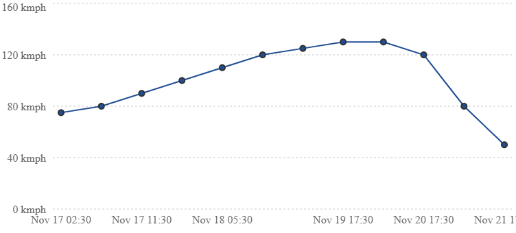
- November 17 evening: Expected to become a Severe Cyclonic Storm.
- November 19 morning: Expected to reach Very Severe Cyclonic Storm intensity.
- November 19–20: Sustained winds could reach 120–130 kmph.
- November 20 around 11:30 a.m.: Expected landfall between Nellore and Tuni, according to the bulletin.
- November 21: Forecast weakening.
Forecast models show differences in future track
Most numerical weather prediction models indicate that Akvan could strengthen into a severe cyclonic storm around 5:30 p.m. on November 17, followed by further intensification into a very severe cyclonic storm around 5:30 a.m. on November 19.
However, considerable differences remain among forecast models regarding the system’s future movement, intensity and landfall location.
The forecast confidence assessment gives a high level of confidence in the current location and intensity. Confidence in the forecast track is rated moderate to high, while confidence in future intensity is also moderate to high.
With the system expected to continue moving northwestwards, further official updates will be important in determining its eventual path and potential impact along the Indian east coast.