
Depression in Bay of Bengal Likely to Intensify into Cyclonic Storm on November 16
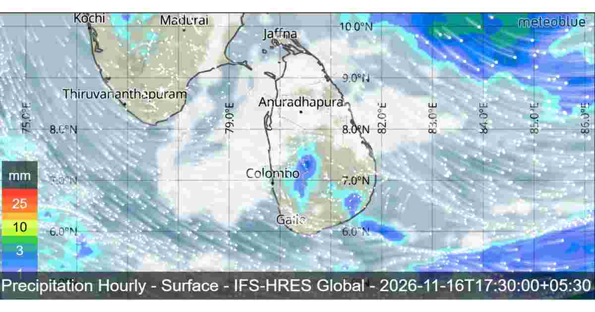
Sri Lanka is expected to experience unsettled weather conditions on November 16, 2026, as a depression over the Bay of Bengal continues to develop and move northwestwards, away from the island. According to the Department of Meteorology, the system is likely to intensify into a Cyclonic Storm by November 16 and may further strengthen into a Severe Cyclonic Storm by November 17.
Confirms that the low-pressure system located east of Sri Lanka has developed into a depression. Sunday, the system was positioned approximately 630 kilometres northeast of Trincomalee, slightly east of the northeast direction.
Meteorological forecasts indicate that the depression is expected to continue moving northwestwards while remaining well away from Sri Lanka’s eastern coastline. It is likely to intensify into a Deep Depression by the morning of November 16 before developing into a Cyclonic Storm over the southern and adjoining west-central Bay of Bengal by the evening. Further intensification into a Severe Cyclonic Storm is possible over the west-central Bay of Bengal by November 17.
Although the system is forecast to move away from the island, its influence is expected to bring cloudy skies and showers to many parts of Sri Lanka.
Rainy and Cloudy Weather Expected Across Sri Lanka
Cloudy skies are expected to prevail across the entire island on November 16 due to the influence of the developing weather system.
Several spells of showers are forecast in the Northern, North-Central, Eastern, Western, Sabaragamuwa and North-Western provinces. Rainfall is also expected in the Kandy, Nuwara Eliya, Galle and Matara districts.
Meanwhile, showers or thundershowers may develop at a few places in the Uva Province and Hambantota district after 2.00 p.m.
Misty conditions may occur in most parts of the island during the early morning hours. Motorists are advised to remain cautious when travelling through areas with reduced visibility.
The public is requested to take necessary precautions to minimize possible damage caused by temporary localized strong winds and lightning during thundershowers.

Severe Weather Warning for Sea Areas Around Sri Lanka
The developing depression is also expected to affect sea conditions around Sri Lanka over the next 24 hours. According to the Department of Meteorology, showers or thundershowers will occur in the sea areas extending from Kankasanthurai to Galle via Trincomalee, Batticaloa and Hambantota.
Winds around the island will be north-westerly or northerly, with speeds ranging between 30 and 40 kmph. However, wind speeds may increase up to 60 kmph at times in the sea areas extending from Kankasanthurai to Hambantota via Trincomalee and Batticaloa. In other surrounding sea areas, wind speeds may occasionally increase up to 50 kmph.
Sea conditions are expected to become rough at times in the coastal waters extending from Kankasanthurai to Hambantota via Trincomalee and Batticaloa. The other sea areas around the island may become fairly rough at times.
Furthermore, temporarily strong gusty winds reaching 60–70 kmph and very rough sea conditions can be expected during thundershowers. These conditions may create dangerous situations for fishing vessels and other marine activities.

Fishing and Naval Communities Advised to Avoid Dangerous Sea Areas
In view of the developing depression and expected deterioration of sea conditions, the Department of Meteorology has issued an important advisory for naval and fishing communities.
Fishing vessels and naval communities are warned not to venture into the deep-sea areas bounded by 05°N–15°N and 80°E–90°E. They are also advised to avoid the sea areas extending from Kankasanthurai to Hambantota via Trincomalee and Pottuvil.
Fishing and naval communities already operating in these affected sea areas are strongly advised to move towards safer locations without delay.
They are also requested to closely monitor future weather forecasts and official bulletins issued by the Department of Meteorology for further updates on the movement and intensity of the developing system.
What to Expect on November 16 and 17?
The depression is expected to continue its northwestward movement, gradually strengthening over the Bay of Bengal. The system may become a Deep Depression on the morning of November 16, followed by Cyclonic Storm development by the evening. Further intensification into a Severe Cyclonic Storm is possible by November 17.
Although the system is expected to move away from Sri Lanka, its influence will continue to affect the island’s weather and surrounding sea areas.
The public, particularly residents in areas expecting showers and thundershowers, should remain alert to official weather updates and take appropriate precautions against lightning and localized strong winds.