
Severe Cyclonic Storm Murasu Heads Towards Andhra Pradesh Coast; Landfall Expected Near Ongole
Severe Cyclonic Storm Murasu is moving north-northwestwards over the west-central Bay of Bengal and is expected to cross the south Andhra Pradesh coast between Nellore and Narsapur, close to Ongole, during the night of November 2 or early hours of November 3, according to the latest bulletin from the India Meteorological Department (IMD).
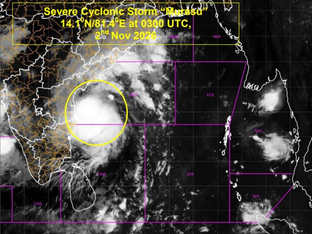
The cyclone was located at 1:30 p.m. on November 2 near 14.1°N latitude and 81.4°E longitude, over the west-central Bay of Bengal. At the time, its centre was approximately 160 kilometres east-southeast of Nellore, 180 kilometres northeast of Kavali, 180 kilometres east-southeast of Chennai, 210 kilometres southeast of Ongole and 240 kilometres south of Machilipatnam.
Murasu was moving north-northwestwards at around 26 kilometres per hour. Its maximum sustained wind speed was estimated at 100–110 km/h, with gusts reaching 120 km/h, making it a Severe Cyclonic Storm.

Landfall expected between Nellore and Narsapur
The IMD forecasts that Murasu will continue moving north-northwestwards before crossing the south Andhra Pradesh coast between Nellore and Narsapur, close to Ongole, between 11:30 p.m. on November 2 and 3:30 a.m. on November 3 .
The storm is expected to maintain severe cyclonic storm intensity during landfall, with maximum sustained winds of 100–110 km/h and gusts reaching 120 km/h.
After crossing the coast, the system is forecast to weaken gradually as it moves inland. The IMD’s forecast indicates that Murasu could weaken into a cyclonic storm on November 3, followed by a deep depression and then a depression by November 4.

Murasu forecast track and wind speeds
The following positions and wind speeds are based on the forecast table in the latest bulletin. Times have been converted from UTC to Indian Standard Time (IST).
| Date and time (IST) | Forecast position | Maximum sustained wind | System intensity |
|---|---|---|---|
| Nov 2, 8:30 a.m. | 14.1°N, 81.4°E | 100–110 km/h, gusting to 120 | Severe Cyclonic Storm |
| Nov 2, 11:30 a.m. | 14.2°N, 81.1°E | 100–110 km/h, gusting to 120 | Severe Cyclonic Storm |
| Nov 2, 5:30 p.m. | 14.6°N, 80.6°E | 100–110 km/h, gusting to 120 | Severe Cyclonic Storm |
| Nov 2, 11:30 p.m. | 15.1°N, 80.1°E | 100–110 km/h, gusting to 120 | Severe Cyclonic Storm |
| Nov 3, 5:30 a.m. | 15.5°N, 79.8°E | 70–80 km/h, gusting to 90 | Cyclonic Storm |
| Nov 3, 5:30 p.m. | 16.0°N, 79.5°E | 55–65 km/h, gusting to 75 | Deep Depression |
| Nov 4, 5:30 a.m. | 16.5°N, 79.2°E | 35–45 km/h, gusting to 55 | Depression |
The forecast indicates that the system is expected to lose strength after landfall. However, the timing and intensity remain subject to changes in subsequent IMD updates.
Storm surge warning for coastal Andhra Pradesh
The IMD has also issued a storm surge warning for parts of the south Andhra Pradesh coastline.
A storm surge exceeding 0.5 metres above the astronomical tide is likely to inundate low-lying coastal areas from the evening of November 2 until the morning of November 3.
The expected peak surge is around 1.0–1.5 metres above the astronomical tide during the night of November 2 and the early hours of November 3. The maximum surge is forecast over Bapatla, Krishna and Prakasam districts.
Residents in vulnerable coastal and low-lying locations should closely follow official warnings and instructions from local authorities.
Weather conditions over the Bay of Bengal
Satellite imagery at 3:00 a.m. UTC on November 2 indicated that the cyclone had a T3.5 intensity. Deep convective cloud activity was concentrated towards the northwest of the system, with intense to very intense convection over the west Bay of Bengal.
The bulletin also noted that cold and dry air was entering the outer part of the system, while warm and moist air continued to feed its core. These atmospheric conditions, together with the cyclone’s interaction with land, are expected to influence its further development and weakening.
The estimated central pressure of Murasu was 996.0 hPa, with maximum sustained winds of 55 knots and gusts reaching 65 knots.
What is expected after landfall?
According to the IMD’s forecast guidance, Murasu is likely to weaken after crossing the Andhra Pradesh coast. The system is expected to move inland and gradually lose its cyclonic strength, potentially becoming a deep depression by November 3 and a depression by November 4.
The IMD has assessed the confidence level in the current location and intensity, forecast track and forecast intensity as high.
The forecast landfall window is between 11:30 p.m. on November 2 and 3:30 a.m. on November 3 (IST). This remains a forecast window, not confirmation that landfall has already occurred.
Source: India Meteorological Department (IMD), latest bulletin issued on November 2, 2026.