
Deep Depression Over Bay of Bengal to Affect Sri Lanka with Rough Seas and Strong Winds
A deep depression over the southwest Bay of Bengal continues to influence weather conditions across Sri Lanka and surrounding sea areas. According to the latest observations, the system moved nearly northwestwards at a speed of about 10 km per hour during the past six hours. As of 5.30 a.m. on 9 January 2026, the centre of the deep depression was located near latitude 7.1°N and longitude 83.3°E, approximately 160 km east of Pottuvil, 190 km east-southeast of Batticaloa, 260 km east-northeast of Hambantota, and 280 km southeast of Trincomalee.

Weather authorities state that the system is very likely to continue moving northwestwards and is expected to cross the northern coast of Sri Lanka between Trincomalee and Jaffna between 11.30 a.m. and 5.30 p.m. on 10 January 2026. As the deep depression approaches the island, cloudy skies, heavy rainfall, strong winds, and rough sea conditions are expected to intensify.
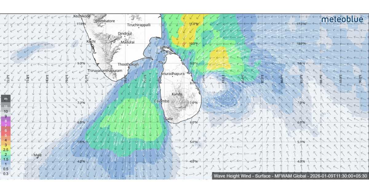
The estimated central pressure of the system is around 1004 hPa, while the maximum sustained wind speed is about 30 knots. Sea conditions remain very rough, with significant wave heights ranging from 4.0 to 6.0 metres, especially over the eastern and northern sea areas. Ship observations taken during the early morning hours of 9 January indicate strong winds and reduced pressure, confirming the continued strength of the system.

Satellite imagery from INSAT-3DS, analyzed shows the deep depression maintaining an intensity level of T2.0. Scattered to broken low and medium-level cloud formations, along with embedded intense to very intense convective activity, are present over the southern Bay of Bengal, adjoining equatorial Indian Ocean, and Sri Lanka. Moderate to intense convection is also affecting the Palk Strait, Gulf of Mannar, and adjoining coastal regions, increasing the risk of heavy showers and gusty winds.
Due to hazardous sea conditions, naval and fishing communities are strictly warned not to venture into deep or shallow sea areas around the island until further notice. Fishermen currently at sea are advised to return to the nearest harbour as early as possible and remain alert to official weather updates.

Regarding rainfall, showers or thundershowers are expected at times in sea areas off the coast extending from Chilaw to Hambantota, passing through Mannar, Kankasanthurai, Trincomalee, and Pottuvil. In other surrounding sea areas, showers or thundershowers may occur mainly during the evening and night hours.
Winds over the sea will be north-easterly, with speeds of 35–45 kmph, increasing to 60–70 kmph at times, particularly during thundershowers. The sea around the island will remain rough to very rough, with wave heights of about 2.5 to 3.5 metres along the eastern and southeastern coasts.
The Department of Meteorology continues to closely monitor the system, and the general public and maritime communities are urged to stay vigilant and follow future advisories issued throughout the day and night.