
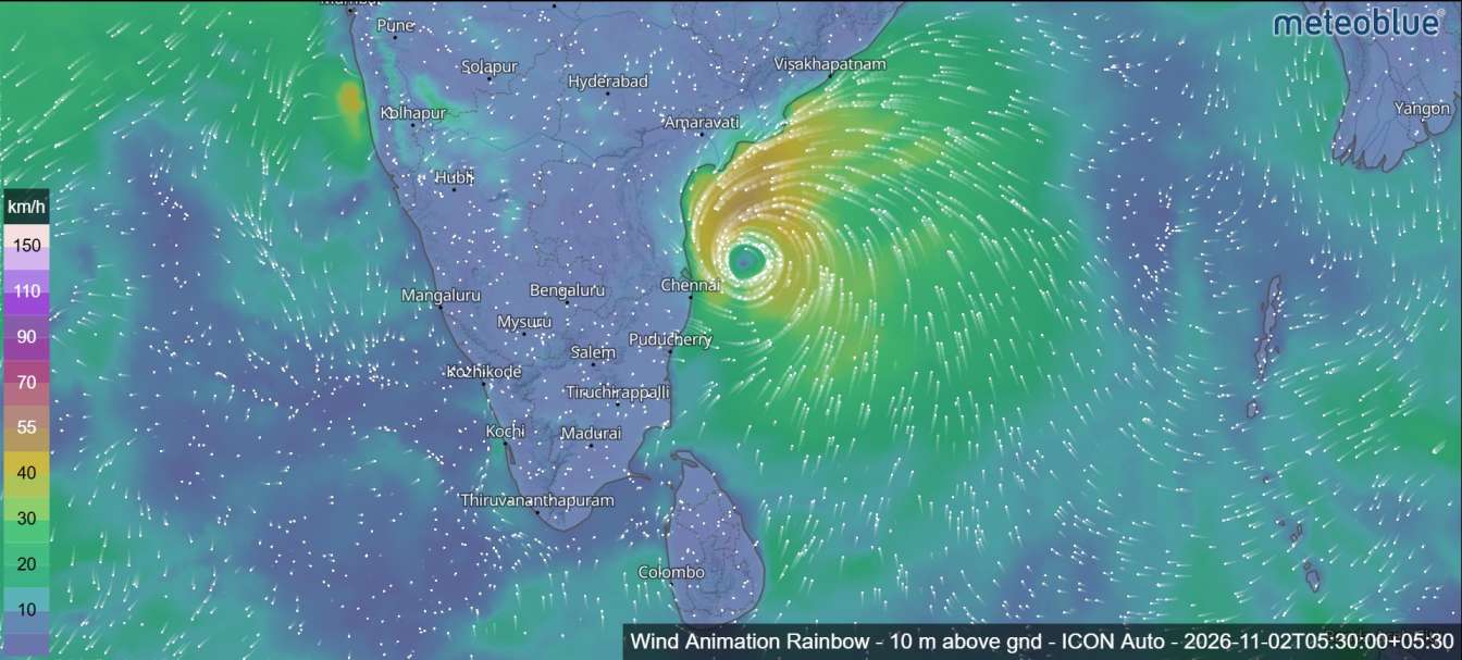
Cyclone Murasu Intensifies Over Bay of Bengal, Andhra Pradesh Coast Faces November 3 Landfall Threat
The deep depression over the Bay of Bengal has intensified into Cyclonic Storm Murasu, raising concerns along the southern Andhra Pradesh coastline as the system continues moving towards India. The India Meteorological Department (IMD) confirmed the development at 11:30 a.m. on November 1, 2026.
The newly formed cyclone is expected to strengthen further into a severe cyclonic storm over the west-central Bay of Bengal on November 2. Current forecasts indicate that it could cross the southern Andhra Pradesh coast between Nellore and Narsapur on the morning of November 3, bringing powerful winds and heavy rainfall to coastal areas.
The system is moving west-northwestwards, and meteorologists are continuing to monitor its development and projected path.

Cyclone Murasu Forms Over the Bay of Bengal
According to the latest meteorological update, the deep depression over the southwest and adjoining west-central Bay of Bengal intensified into Cyclonic Storm Murasu at 11:30 a.m. on November 1.
At the time of the latest forecast position, the system was located near 11.8°N latitude and 86.3°E longitude, with maximum sustained winds of 65–75 km/h and gusts reaching 85 km/h.
The system developed from a depression over the southeast Bay of Bengal before strengthening into a deep depression and subsequently becoming a named cyclonic storm.
The name Murasu, meaning “drum” in Tamil, was proposed by India.


Andhra Pradesh Coast Faces Possible Cyclone Landfall on November 3
Cyclone Murasu is forecast to continue moving west-northwestwards before strengthening further over the Bay of Bengal.
The IMD expects the system to become a severe cyclonic storm over the west-central Bay of Bengal on November 2.
It is then likely to approach the southern Andhra Pradesh coastline during the early hours of November 3 before crossing the coast between Nellore and Narsapur by the morning.
At the time of the expected landfall, maximum sustained wind speeds could reach 100–110 km/h, with gusts of up to 120 km/h.
The forecast track and intensity remain subject to change as the cyclone develops.
Cyclone Murasu: Latest Forecast Track and Wind Speeds
The following forecast shows the expected development and movement of Cyclone Murasu. All times are in Indian Standard Time (IST).
| Date and Time (IST) | Cyclone Category | Maximum Sustained Wind Speed |
|---|---|---|
| November 1 – 11:30 a.m. | Cyclonic Storm | 65–75 km/h, gusting to 85 km/h |
| November 1 – 5:30 p.m. | Cyclonic Storm | 70–80 km/h, gusting to 90 km/h |
| November 2 – 5:30 a.m. | Cyclonic Storm | 80–90 km/h, gusting to 100 km/h |
| November 2 – 5:30 p.m. | Severe Cyclonic Storm | 90–100 km/h, gusting to 110 km/h |
| November 3 – 5:30 a.m. | Severe Cyclonic Storm | 100–110 km/h, gusting to 120 km/h |
| November 3 – 5:30 p.m. | Cyclonic Storm | 70–80 km/h, gusting to 90 km/h |
| November 4 – 5:30 a.m. | Deep Depression | 50–60 km/h, gusting to 70 km/h |
Forecast values are subject to reision in subsequent IMD bulletins.
Warm Ocean Waters and Atmospheric Conditions Support Intensification
Meteorological observations indicate that favourable oceanic and atmospheric conditions are supporting the development of Cyclone Murasu.
Sea surface temperatures are around 29°C over the Andaman Sea and Bay of Bengal. Ocean heat content is estimated at approximately 60–70 KJ/cm² in some areas, with higher values of around 100–120 KJ/cm² across parts of the central and southern Bay of Bengal.
The Madden-Julian Oscillation (MJO) is currently in Phase 3, with an amplitude greater than one. It is expected to remain in this phase over the next five days, supporting enhanced atmospheric convection and cyclone development.
The influence of Equatorial Rossby waves and Kelvin waves, together with westerly wind anomalies, is also contributing to an environment favourable for further intensification.
Satellite observations have identified organised spiral cloud bands and intense convection around the cyclone.
Cyclone Movement Could Change After Landfall
Numerical weather prediction models indicate that Cyclone Murasu is likely to move west-northwestwards towards the southern Andhra Pradesh coast.
After crossing the coastline, the system may gradually change direction towards the north and northeast under the influence of an upper-level subtropical ridge and an approaching upper-air trough.
Wind shear conditions are currently low to moderate around the cyclone centre, supporting further development. However, stronger wind shear is expected along parts of its projected path and over inland areas.
The intrusion of relatively dry and cold air from the western sector could also contribute to the weakening of the system after landfall.
IMD Continues Monitoring Cyclone Murasu
The India Meteorological Department is continuing to monitor Cyclone Murasu using satellite observations, numerical weather prediction models and other meteorological data.
The forecast indicates that the system could strengthen into a severe cyclonic storm before approaching the Andhra Pradesh coastline.
Coastal communities and people in potentially affected areas are advised to follow the latest official weather bulletins and instructions issued by local authorities.
The cyclone’s track, intensity and expected landfall timing may change as new observations become available.