
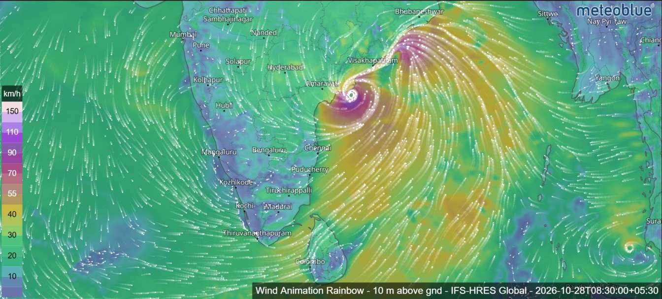
Cyclone Arnab was moving dangerously close to the Andhra Pradesh coastline late on October 27, with landfall expected near the coast between Bapatla and Machilipatnam. The very severe cyclonic storm was packing sustained winds of 125–135 km/h, with gusts reaching 150 km/h, while authorities warned of destructive winds, heavy rainfall and possible coastal inundation.


According to the India Meteorological Department (IMD) bulletin, the storm was centred over the west-central Bay of Bengal at 11:30 p.m. IST on October 27, near latitude 16.3°N and longitude 82.1°E. It was approximately 50 kilometres east-southeast of Narsapur, 70 kilometres south of Kakinada, 100 kilometres east of Machilipatnam, 185 kilometres east-northeast of Bapatla and 200 kilometres south-southwest of Visakhapatnam.
The system had continued moving northwestwards and was expected to cross the Andhra Pradesh coast between Bapatla and Machilipatnam, close to Yanam, as a very severe cyclonic storm. The bulletin indicated that the landfall process could begin within the following one to two hours, with the system likely to cross during the early hours of October 28.
Cyclone Arnab Landfall: Timing, Location and Wind Speeds
The IMD forecast placed the cyclone’s landfall near the Andhra Pradesh coast around 2100 UTC on October 27, equivalent to approximately 2:30 a.m. Indian Standard Time on October 28. The bulletin also described the system as very close to the coastline, with landfall expected shortly afterwards.
At the time of the bulletin, maximum sustained wind speeds were estimated at 140–150 km/h, with gusts reaching 170 km/h in the storm’s vicinity. The forecast indicated that winds associated with the system could reach 125–135 km/h, with gusts up to 150 km/h, during the expected coastal crossing.
The areas around Bapatla, Machilipatnam, Kakinada, Yanam and Narsapur were among the locations highlighted by the cyclone’s projected position and track. Residents in coastal and low-lying communities were urged to follow official warnings and emergency instructions.
Cyclone Arnab Forecast to Weaken After Landfall
The IMD expected Cyclone Arnab to weaken progressively after crossing the coast as it moved inland.
The forecast bulletin outlined the following expected changes in the system’s intensity:
- October 27, 11:30 p.m. IST: Very severe cyclonic storm, with winds of 140–150 km/h and gusts up to 170 km/h.
- October 28, 5:30 a.m. IST: Very severe cyclonic storm, with winds of 125–135 km/h and gusts up to 150 km/h.
- October 28, 11:30 a.m. IST: Cyclonic storm, with winds of 80–90 km/h and gusts up to 100 km/h.
- October 28, 5:30 p.m. IST: Deep depression, with winds of 50–60 km/h and gusts up to 70 km/h.
- October 28, 11:30 p.m. IST: Depression, with winds of 40–50 km/h and gusts up to 60 km/h.
- October 29, 5:30 a.m. IST: Depression, with winds of 30–40 km/h and gusts up to 55 km/h.
- October 29, 5:30 p.m. IST: Well-marked low-pressure area, with winds of 20–30 km/h and gusts up to 40 km/h.
These are forecast stages rather than confirmed observations. The cyclone’s actual weakening rate and inland movement may differ from the projected timeline.
Storm Surge Threatens Low-Lying Coastal Areas
One of the major concerns associated with Cyclone Arnab was the risk of storm surge during landfall.
The IMD warned that storm surge water could reach approximately 1.5–2.5 metres above the astronomical tide and inundate low-lying coastal areas of Andhra Pradesh. The maximum surge was expected near Kakinada and Yanam.
Along the mouth of the Godavari River, the bulletin indicated that the surge height could reach approximately 2–3.5 metres. Such conditions could cause seawater to move inland into vulnerable coastal areas, potentially threatening homes, roads, agricultural land and other infrastructure.
People living in low-lying coastal settlements were advised to take official evacuation and safety instructions seriously. Coastal flooding risks can remain significant even as wind conditions begin to change.
Strong Winds Expected to Gradually Weaken
The wind warning indicated that gale-force winds of 140–150 km/h, with gusts up to 170 km/h, were prevailing near the cyclone. These winds were expected to decrease gradually as the system crossed the coast and weakened.
The forecast suggested that wind speeds could fall to around 90 km/h by 1200 UTC on October 28. By 0600 UTC on October 29, squally winds of 30–40 km/h, with gusts up to 55 km/h, were expected, followed by further weakening.
Even after landfall, strong winds, heavy rainfall and damaged infrastructure could continue to create dangerous conditions. Fallen trees, damaged power lines, flooding and blocked roads may pose risks in affected communities.
Doppler Radar Tracks the Cyclone
The bulletin reported that the Doppler Weather Radar at Machilipatnam continued to monitor the storm. Radar imagery at 1800 UTC on October 27 showed a significant reduction in convective activity around the cloud region, while outer rainbands were strengthening over the northern sector.
The cyclone’s intensity was assessed at T4.0. Satellite imagery showed scattered to broken cloud bands and intense to very intense convection over parts of the west-central Bay of Bengal and adjoining coastal areas.
The bulletin also described sea-surface temperatures of approximately 29–30°C over the relevant parts of the Bay of Bengal, conditions that can support tropical cyclone development. It noted that atmospheric factors, including upper-level divergence, low-level convergence and wind shear, were relevant to the system’s continued development and subsequent weakening.
Forecast Track and Confidence
Meteorological guidance indicated that Cyclone Arnab was likely to continue northwestwards towards the Andhra Pradesh coast before moving inland. The bulletin assessed confidence in the current location and intensity as high, while confidence in the forecast track and future intensity was rated moderate to high.
The forecast also highlighted the possibility of heavy rainfall as the cyclone’s rainbands moved across coastal Andhra Pradesh and adjoining areas. The combination of strong winds, coastal inundation and rainfall-related impacts made the landfall period particularly important for preparedness.
Residents should continue to follow the latest advisories from the India Meteorological Department and instructions from local disaster management authorities. The projected landfall location, timing and intensity can change, and official updates remain essential as the system crosses the coast.
Cyclone Arnab’s immediate threat was expected to peak during landfall, followed by gradual weakening over land. However, the risk of flooding, storm surge and wind-related damage could persist after the centre of the cyclone moves inland.