
Cyclone Arnab Update
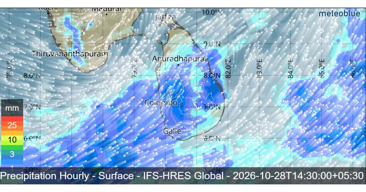
Sri Lanka is expected to experience continued unsettled weather on 28 October 2026 as Very Severe Cyclonic Storm Arnab moves towards the eastern coast of India. The cyclone is expected to cross the Indian landmass through Andhra Pradesh around 11.30 a.m. on 28 October as a very severe cyclonic storm. Although the system is moving away from Sri Lanka, strong winds, showers and rough sea conditions are expected to affect several areas.
Cyclone Arnab Location and Expected Movement
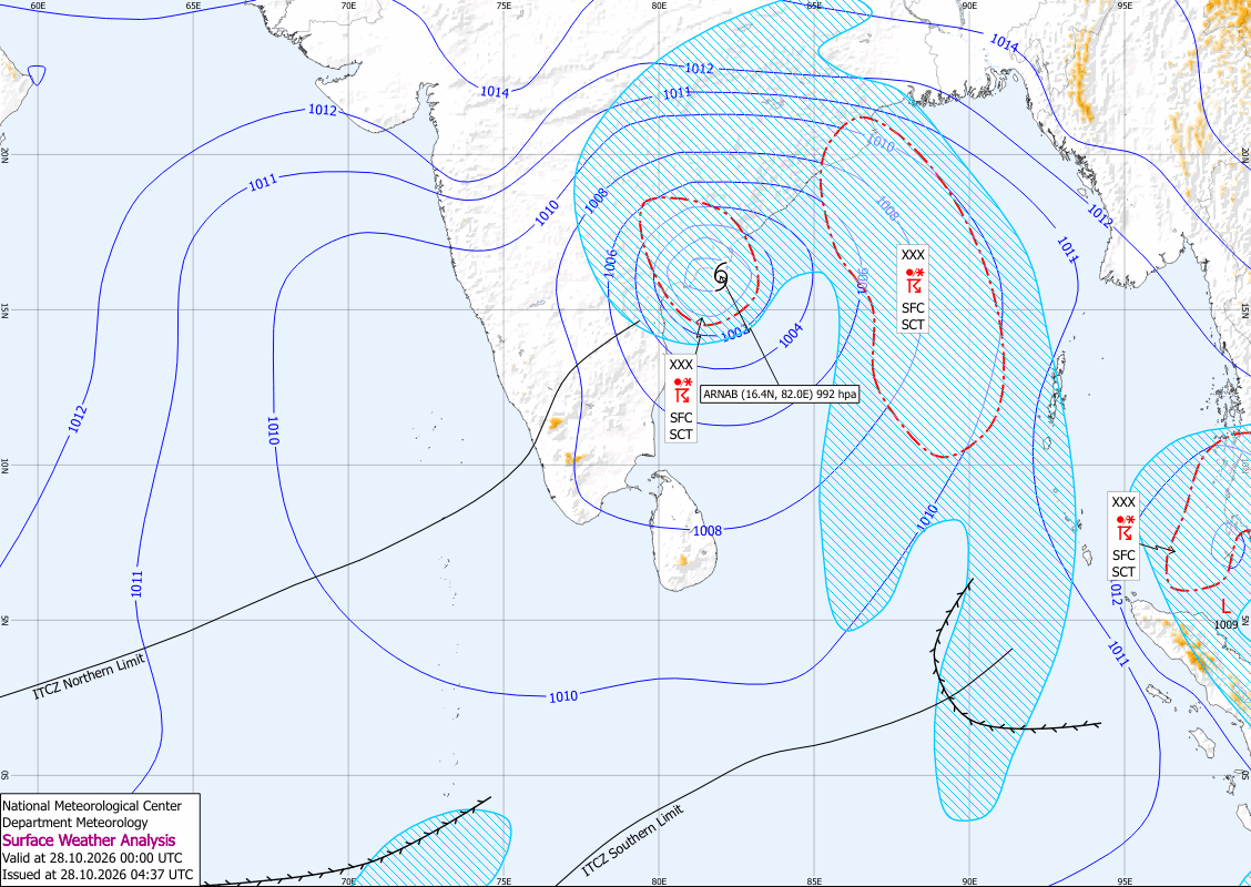
At 11.30 a.m. on 27 October, Cyclone Arnab was located over the west-central Bay of Bengal near latitude 16.0°N and longitude 84.3°E, approximately 820 kilometres northeast of Kankasanthurai.
The cyclone is very likely to cross the Indian coast through Andhra Pradesh around 11.30 a.m. on 28 October. The Department of Meteorology expects the influence of the system on Sri Lanka’s weather to gradually decrease from 28 October. However, the public and maritime communities should continue to follow official weather updates because hazardous winds and sea conditions may persist.

Rainfall Forecast for Sri Lanka
Several spells of showers are expected in the Western and Sabaragamuwa provinces and in the Kandy, Nuwara Eliya, Galle and Matara districts. These areas may experience intermittent rainfall throughout the day.
Showers or thundershowers are also expected at a few places in the Uva Province and in the Batticaloa and Ampara districts after 1.00 p.m.
Strong winds of around 40–50 kmph may occur at times over the western slopes of the Central Hills, the Northern, North-Central and North-Western provinces, and the Trincomalee and Hambantota districts.
Residents are advised to remain alert to temporary localized strong winds and lightning during thundershowers. Appropriate precautions should be taken to minimize potential damage and avoid unnecessary exposure during severe weather.
Cyclone Arnab: Dangerous Sea Conditions Expected
The Department of Meteorology has issued a serious warning for naval and fishing communities because of hazardous sea conditions associated with Cyclone Arnab.
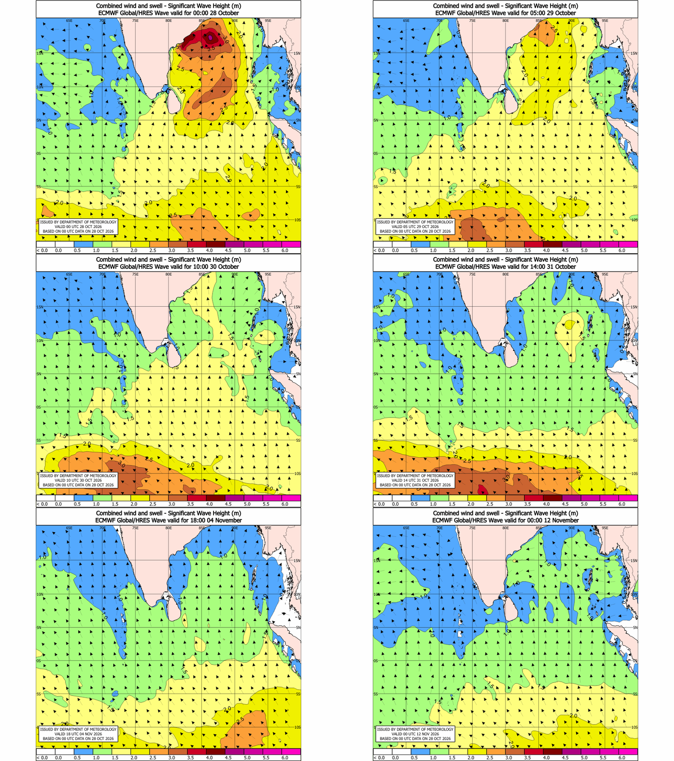
Wind speeds in the sea area bounded by latitudes 10°N to 20°N and longitudes 80°E to 90°E may increase to 80–100 kmph at times. Heavy thundershowers are possible, while wave heights may reach approximately 3–4 metres. Sea conditions in this region are expected to become very rough.
Naval and fishing communities are warned not to venture into these affected sea areas until further notice. Those already operating in the specified region are advised to move away from the affected waters and follow subsequent bulletins issued by the Department of Meteorology.
Wind and Sea Conditions Around Sri Lanka
Showers or thundershowers are expected at several places in the sea areas around the island. South-westerly winds will generally prevail at speeds of 30–40 kmph.
Wind speeds may increase to 60–65 kmph at times in the deep and shallow sea areas extending from Puttalam to Mullaitivu via Kankasanthurai and from Galle to Pottuvil via Hambantota. Winds in other surrounding sea areas may reach 50 kmph at times.
The sea areas along these northern and southern coastal stretches are expected to become very rough at times, while other sea areas may also be rough. Wave heights may reach approximately 2–2.5 metres in the sea areas extending from Matara to Pottuvil via Hambantota.
Temporarily strong gusty winds of 60–70 kmph and very rough seas may occur during thundershowers.
Public Safety Advice
The public should remain attentive to official weather forecasts and take precautions against strong winds, lightning and sudden changes in weather. Fishermen and naval personnel should strictly follow maritime warnings and avoid the affected sea areas until authorities issue further instructions.
Although Cyclone Arnab’s influence on Sri Lanka is expected to gradually decrease from 28 October, dangerous marine conditions may continue in the specified regions. Following official updates from the Department of Meteorology remains essential for public safety.