
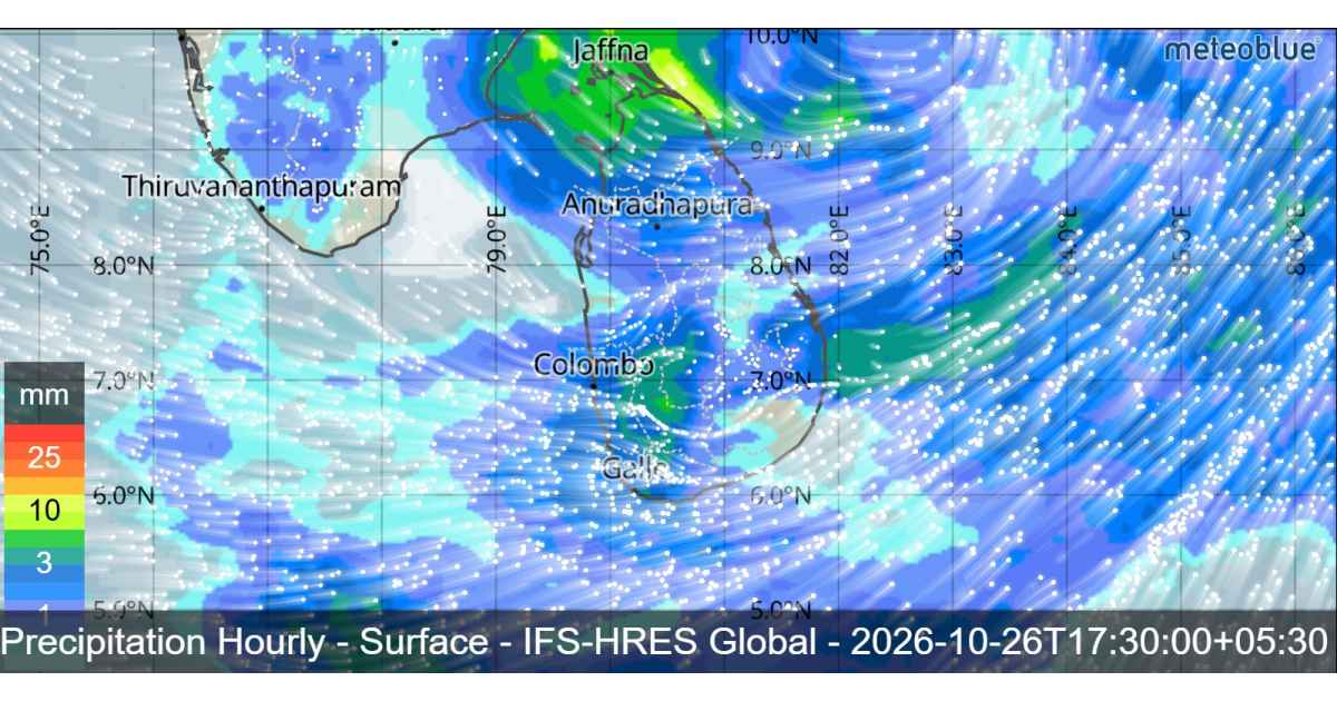
Heavy Rain, Strong Winds and Rough Seas Expected
Sri Lanka is expected to experience unsettled weather conditions on 26 October 2026, with heavy rainfall, strong winds and rough seas forecast across several parts of the island. According to the Department of Meteorology, a developing weather system over the Bay of Bengal is expected to influence regional wind patterns, increasing rainfall over southwestern parts of Sri Lanka during the next few days.

Deep Depression Over the Bay of Bengal

The depression over the east-central and adjoining southeastern Bay of Bengal has intensified into a deep depression.The system was centred near latitude 15.3°N and longitude 89.7°E after moving westwards.
The system is expected to move nearly westwards and intensify into a cyclonic storm over the east-central and adjoining southeastern Bay of Bengal today. It is then likely to move west-northwestwards and develop into a severe cyclonic storm over the west-central Bay of Bengal by 27 October 2026.
Although the system is not expected to have a direct impact on Sri Lanka, its associated wind flow is likely to influence local weather conditions. An increase in rainfall is expected over the southwestern parts of the island during the coming days.

Heavy Rainfall Expected Across Several Provinces
Showers or thundershowers will occur at times in the Northern, Western, Sabaragamuwa, Southern, North-Western, Central and North-Central provinces, as well as in the Trincomalee district. Heavy rainfall exceeding 100 mm is likely at some locations in these areas.
Meanwhile, showers or thundershowers are expected at several places in the Uva Province and in the Ampara and Batticaloa districts after 1.00 p.m.
The public is advised to remain alert to changing weather conditions, particularly in areas expecting heavy rainfall. Temporary localized strong winds and lightning may accompany thundershowers, increasing the risk of weather-related damage.
The Department of Meteorology requests the public to take adequate precautions to minimize potential damage caused by strong winds and lightning during thunderstorms.
Strong Winds Expected in Several Areas
Strong winds reaching approximately 40–50 kmph may occur at times over the western slopes of the Central Hills, the Northern, North-Central and North-Western provinces, and the Trincomalee and Hambantota districts.
Residents, commuters and outdoor workers should exercise caution during periods of strong winds, especially when thunderstorms develop.
Sea Areas Forecast: Rough Seas and Strong Winds
The deep depression over the Bay of Bengal is also expected to influence sea conditions around Sri Lanka. Showers or thundershowers will occur at several places in the sea areas surrounding the island during the next 24 hours.
Southwesterly winds are expected, with speeds ranging from 30–40 kmph. Wind speeds may increase to 60–65 kmph in sea areas extending from Trincomalee to Mannar via Kankasanthurai and from Matara to Pottuvil via Hambantota. In other sea areas, wind speeds may increase to around 50 kmph at times.
Sea conditions are expected to become very rough at times in the affected coastal areas, while other sea areas may also become rough. Wave heights may increase to approximately 2.0–2.5 metres in sea areas extending from Puttalam to Pottuvil via Colombo, Galle and Matara.
During thundershowers, temporarily strong gusty winds reaching 60–70 kmph and very rough seas can be expected.

Advisory for Naval and Fishing Communities
Naval and fishing communities are warned not to venture into deep-sea areas bounded by latitudes 10°N–20°N and longitudes 80°E–95°E until further notice. Those already operating in these waters are advised to move to safe areas.
Fishing and naval communities should closely follow future weather forecasts and official bulletins issued by the Department of Meteorology.
The public is encouraged to monitor official weather updates as the system develops and to take appropriate precautions against heavy rainfall, strong winds, lightning and hazardous sea conditions.