
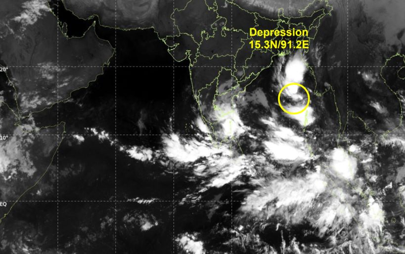
A depression over the east-central Bay of Bengal is forecast to intensify into a very severe cyclonic storm, with Andhra Pradesh and southern Odisha under pre-cyclone watch.
Depression Over Bay of Bengal: Latest Weather Update
A depression over the east-central Bay of Bengal and adjoining southeast Bay of Bengal is moving slowly south-southeastward and is expected to strengthen over the coming days, according to the latest forecast bulletin.
As of 00:00 UTC on October 25, 2026, the system was centred near 15.3°N latitude and 91.2°E longitude. It was moving at approximately 5 km/h, with estimated sustained winds of 40–50 km/h and gusts reaching 60 km/h.
The system was located approximately 440 km northwest of Sri Vijaya Puram in the Andaman Islands and 980 km southeast of Kakinada, Andhra Pradesh.

Cyclone Development Forecast for October 25–29
Weather projections indicate that the depression is likely to move generally southward before turning towards the west-northwest. Further intensification is expected as the system travels across the Bay of Bengal.
The system could develop into a deep depression on October 25 and a cyclonic storm by October 26. It is then forecast to strengthen into a severe cyclonic storm on October 27, potentially reaching very severe cyclonic storm intensity on October 28.
Forecast wind speeds could reach 115–125 km/h, with gusts of up to 140 km/h near the system’s expected peak intensity.
The system is projected to move towards the west-central Bay of Bengal and approach the Andhra Pradesh coast near October 28. Forecast guidance indicates a possible crossing between Bapatla and Visakhapatnam, including the Yanam area. However, the projected track and landfall details may change as new observations become available.
Andhra Pradesh and Odisha Under Watch

Authorities and residents in coastal Andhra Pradesh and adjoining southern Odisha should closely follow official weather updates as the system develops. If the forecast intensification occurs, coastal areas could face strong winds, rough seas and heavy rainfall.
The latest assessment indicates moderate-to-high confidence in the forecast track and intensity, although uncertainty remains over the system’s eventual strength and movement.
What Is Driving the Intensification?
Meteorological indicators suggest that conditions over the Bay of Bengal may support further cyclone development. Warm sea-surface temperatures, favourable atmospheric circulation and supportive wind patterns could help the system gain strength.
The next several days will be important in determining the cyclone’s final path and potential coastal impacts. Residents, fishermen and maritime operators should follow official warnings and safety instructions issued by the relevant weather and disaster-management authorities.
This forecast is based on the bulletin available for October 25, 2026. The projected cyclone track, intensity and landfall timing remain subject to change.