
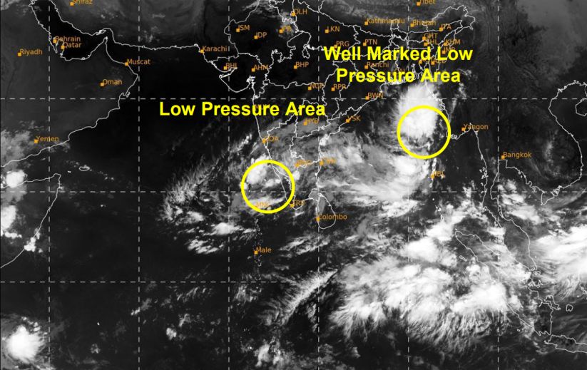
A developing weather system over the Bay of Bengal could strengthen into a cyclonic storm by the morning of October 26, 2026, as meteorologists monitor its west-northwestward movement towards India’s eastern coastline.
According to the tropical weather outlook issued on October 24, the well-marked low-pressure area over the east-central and adjoining southeastern Bay of Bengal is expected to intensify into a depression today. Further strengthening into a deep depression is likely on October 25, followed by the possible formation of a cyclonic storm over the west-central Bay of Bengal by October 26.
The system could continue moving west-northwestwards towards the coast of north Andhra Pradesh and adjoining southern Odisha over the following days.

Bay of Bengal System Shows Signs of Intensification
The latest bulletin indicates that the well-marked low-pressure area remained over the east-central and adjoining southeastern Bay of Bengal at 03:00 UTC on October 24.
The system has an estimated central pressure of 1005 hPa, with maximum sustained winds of around 15 knots and gusts reaching 25 knots.
Satellite observations show areas of intense to very intense cloud convection over the east-central and southeastern Bay of Bengal, as well as the Andaman Islands. These conditions are being monitored as forecasters assess the system’s potential to strengthen.
Forecast models show a strong likelihood of further development, although some differences remain over the system’s eventual track and intensity.
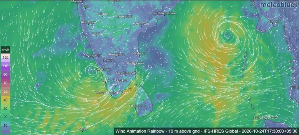
Weather Systems Also Monitored Over the Arabian Sea
The outlook also identifies a low-pressure area over the southeastern Arabian Sea and adjoining Lakshadweep region. The system remained in the same general area on October 24, with an associated cyclonic circulation extending up to approximately 5.8 kilometres above sea level.
Another low-pressure area near the Somali coast over the southwestern Arabian Sea has also been observed.
However, the bulletin assigns a nil probability of these Arabian Sea systems developing into depressions during the next 168 hours.
Weather Outlook for the Coming Days
Meteorological guidance suggests that atmospheric conditions over the Bay of Bengal could support further intensification of the developing system over the coming days.
The current forecast indicates a possible progression from a well-marked low-pressure area to a depression, then a deep depression and potentially a cyclonic storm.
The system’s movement towards the north Andhra Pradesh and adjoining Odisha coasts will continue to be monitored as updated forecasts become available.
Residents, coastal communities and fishing operators should follow the latest advisories issued by the relevant meteorological authorities, as the system’s path and strength may change.